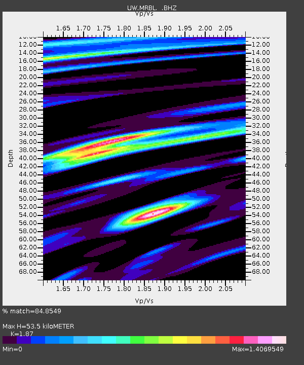
MRBL Marblemount, WA, USA - Earthquake Result Viewer
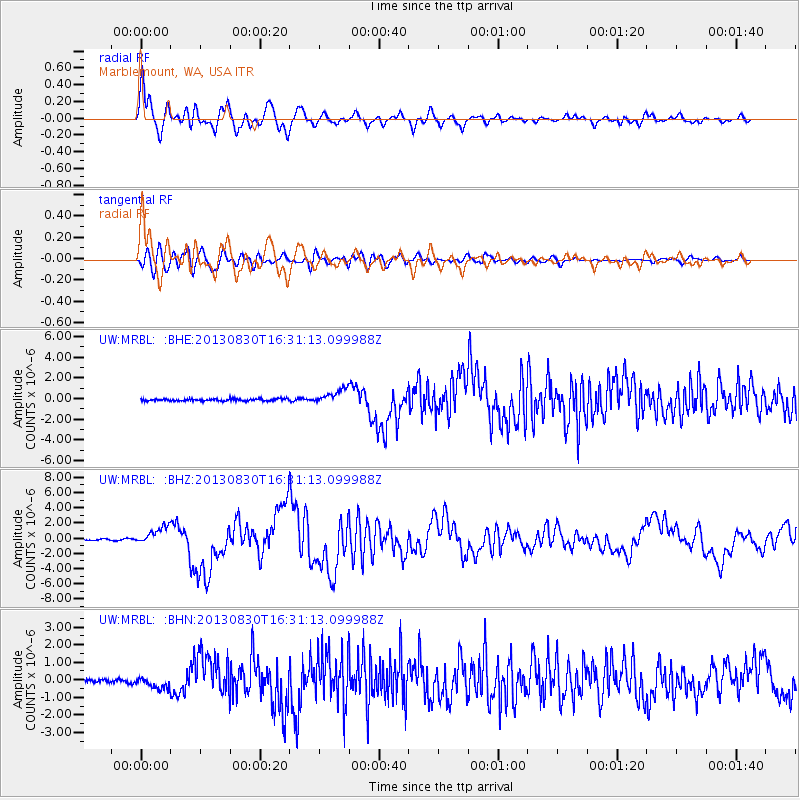
Earthquake location: Andreanof Islands, Aleutian Is.
Earthquake latitude/longitude: 51.5/-175.2
Earthquake time(UTC): 2013/08/30 (242) 16:25:02 GMT
Earthquake Depth: 29 km
Earthquake Magnitude: 7.0 MWW, 6.5 ML, 6.8 MI, 6.9 MWC, 6.9 MWB, 7.0 MWW, 7.0 MI, 7.0 MWC
Earthquake Catalog/Contributor: NEIC PDE/NEIC COMCAT
Network: UW Pacific Northwest Regional Seismic Network
Station: MRBL Marblemount, WA, USA
Lat/Lon: 48.52 N/121.48 W
Elevation: 75 m
Distance: 34.0 deg
Az: 73.437 deg
Baz: 295.789 deg
Ray Param: 0.07790026
Estimated Moho Depth: 53.5 km
Estimated Crust Vp/Vs: 1.87
Assumed Crust Vp: 6.566 km/s
Estimated Crust Vs: 3.511 km/s
Estimated Crust Poisson's Ratio: 0.30
Radial Match: 84.8549 %
Radial Bump: 400
Transverse Match: 73.35586 %
Transverse Bump: 400
SOD ConfigId: 626651
Insert Time: 2014-04-18 05:35:26.082 +0000
GWidth: 2.5
Max Bumps: 400
Tol: 0.001

Signal To Noise

ChannelStoNSTALTA
UW:MRBL: :BHZ:20130830T16:31:13.099988Z12.9795581.1873625E-69.147943E-8
UW:MRBL: :BHN:20130830T16:31:13.099988Z3.01058223.3551547E-71.1144538E-7
UW:MRBL: :BHE:20130830T16:31:13.099988Z6.66624167.029555E-71.0545005E-7
Arrivals
Ps7.7 SECOND
PpPs22 SECOND
PsPs/PpSs29 SECOND