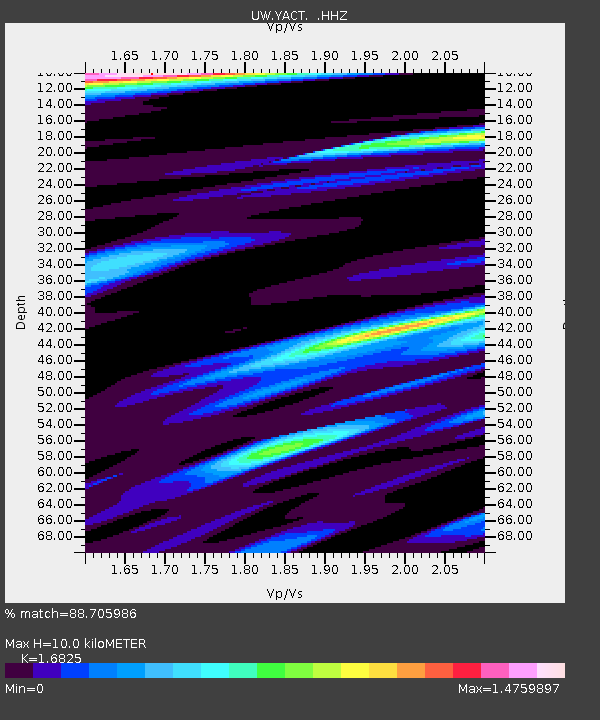
YACT Amboy, WA, USA - Earthquake Result Viewer

Earthquake location: Andreanof Islands, Aleutian Is.
Earthquake latitude/longitude: 51.5/-175.2
Earthquake time(UTC): 2013/08/30 (242) 16:25:02 GMT
Earthquake Depth: 29 km
Earthquake Magnitude: 7.0 MWW, 6.5 ML, 6.8 MI, 6.9 MWC, 6.9 MWB, 7.0 MWW, 7.0 MI, 7.0 MWC
Earthquake Catalog/Contributor: NEIC PDE/NEIC COMCAT
Network: UW Pacific Northwest Regional Seismic Network
Station: YACT Amboy, WA, USA
Lat/Lon: 45.93 N/122.42 W
Elevation: 211 m
Distance: 34.6 deg
Az: 78.033 deg
Baz: 298.901 deg
Ray Param: 0.0775919
Estimated Moho Depth: 10.0 km
Estimated Crust Vp/Vs: 1.68
Assumed Crust Vp: 6.566 km/s
Estimated Crust Vs: 3.903 km/s
Estimated Crust Poisson's Ratio: 0.23
Radial Match: 88.705986 %
Radial Bump: 387
Transverse Match: 73.3276 %
Transverse Bump: 400
SOD ConfigId: 626651
Insert Time: 2014-04-18 05:35:48.786 +0000
GWidth: 2.5
Max Bumps: 400
Tol: 0.001

Signal To Noise

ChannelStoNSTALTA
UW:YACT: :HHZ:20130830T16:31:18.45799Z4.24930951.0010399E-62.3557706E-7
UW:YACT: :HHN:20130830T16:31:18.45799Z2.41986542.8639562E-71.18351885E-7
UW:YACT: :HHE:20130830T16:31:18.45799Z4.6026035.323687E-71.1566688E-7
Arrivals
Ps1.1 SECOND
PpPs3.8 SECOND
PsPs/PpSs4.9 SECOND