YNR Norris Junction, YNP, WY, USA - Earthquake Result Viewer
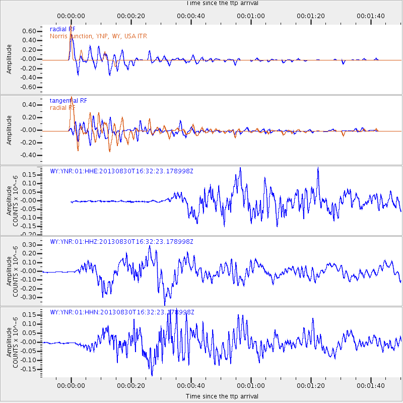
Earthquake location: Andreanof Islands, Aleutian Is.
Earthquake latitude/longitude: 51.5/-175.2
Earthquake time(UTC): 2013/08/30 (242) 16:25:02 GMT
Earthquake Depth: 29 km
Earthquake Magnitude: 7.0 MWW, 6.5 ML, 6.8 MI, 6.9 MWC, 6.9 MWB, 7.0 MWW, 7.0 MI, 7.0 MWC
Earthquake Catalog/Contributor: NEIC PDE/NEIC COMCAT
Network: WY Yellowstone Wyoming Seismic Network
Station: YNR Norris Junction, YNP, WY, USA
Lat/Lon: 44.72 N/110.68 W
Elevation: 2336 m
Distance: 42.4 deg
Az: 72.849 deg
Baz: 303.169 deg
Ray Param: 0.07317168
Estimated Moho Depth: 21.0 km
Estimated Crust Vp/Vs: 2.01
Assumed Crust Vp: 6.35 km/s
Estimated Crust Vs: 3.167 km/s
Estimated Crust Poisson's Ratio: 0.33
Radial Match: 89.39289 %
Radial Bump: 400
Transverse Match: 74.01549 %
Transverse Bump: 400
SOD ConfigId: 626651
Insert Time: 2014-04-18 05:37:16.025 +0000
GWidth: 2.5
Max Bumps: 400
Tol: 0.001

Signal To Noise

ChannelStoNSTALTA
WY:YNR:01:HHZ:20130830T16:32:23.178998Z20.8522783.612124E-81.7322442E-9
WY:YNR:01:HHN:20130830T16:32:23.178998Z3.57372079.0333145E-92.5277058E-9
WY:YNR:01:HHE:20130830T16:32:23.178998Z7.97911931.7168684E-82.1517017E-9
Arrivals
Ps3.5 SECOND
PpPs9.4 SECOND
PsPs/PpSs13 SECOND