You are here: Home > Network List > AU - Australian Seismological Centre Stations List
> Station PSAC2 Pilbara Seismic Array Element C2 > Earthquake Result Viewer
PSAC2 Pilbara Seismic Array Element C2 - Earthquake Result Viewer
| Earthquake location: |
Andreanof Islands, Aleutian Is. |
| Earthquake latitude/longitude: |
51.4/-175.2 |
| Earthquake time(UTC): |
2013/08/30 (242) 16:29:05 GMT |
| Earthquake Depth: |
7.3 km |
| Earthquake Magnitude: |
5.5 MB, 4.4 ML |
| Earthquake Catalog/Contributor: |
NEIC PDE/NEIC COMCAT |
|
| Network: |
AU Australian Seismological Centre |
| Station: |
PSAC2 Pilbara Seismic Array Element C2 |
| Lat/Lon: |
21.56 S/119.90 E |
| Elevation: |
330 m |
|
| Distance: |
92.2 deg |
| Az: |
237.534 deg |
| Baz: |
34.577 deg |
| Ray Param: |
0.041499745 |
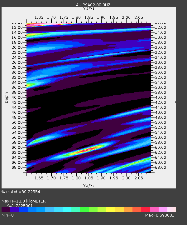
| Estimated Moho Depth: |
10.0 km |
| Estimated Crust Vp/Vs: |
1.73 |
| Assumed Crust Vp: |
6.464 km/s |
| Estimated Crust Vs: |
3.731 km/s |
| Estimated Crust Poisson's Ratio: |
0.25 |
|
| Radial Match: |
80.22954 % |
| Radial Bump: |
336 |
| Transverse Match: |
54.65761 % |
| Transverse Bump: |
400 |
| SOD ConfigId: |
626651 |
| Insert Time: |
2014-04-18 05:38:48.467 +0000 |
| GWidth: |
2.5 |
| Max Bumps: |
400 |
| Tol: |
0.001 |
|

Signal To Noise
| Channel | StoN | STA | LTA |
| AU:PSAC2:00:BHZ:20130830T16:41:43.494019Z | 1.2941651 | 1.1880742E-6 | 9.1802366E-7 |
| AU:PSAC2:00:BH1:20130830T16:41:43.494019Z | 0.7513506 | 3.2667307E-7 | 4.3478116E-7 |
| AU:PSAC2:00:BH2:20130830T16:41:43.494019Z | 2.204553 | 9.134274E-7 | 4.143368E-7 |
| Arrivals |
| Ps | 1.2 SECOND |
| PpPs | 4.1 SECOND |
| PsPs/PpSs | 5.3 SECOND |


