You are here: Home > Network List > EI - Irish National Seismic Network (INSN) Stations List
> Station IDGL INCH ISLAND, CO DONEGAL, IRELAND > Earthquake Result Viewer
IDGL INCH ISLAND, CO DONEGAL, IRELAND - Earthquake Result Viewer
| Earthquake location: |
Andreanof Islands, Aleutian Is. |
| Earthquake latitude/longitude: |
51.4/-175.2 |
| Earthquake time(UTC): |
2013/08/30 (242) 16:29:05 GMT |
| Earthquake Depth: |
7.3 km |
| Earthquake Magnitude: |
5.5 MB, 4.4 ML |
| Earthquake Catalog/Contributor: |
NEIC PDE/NEIC COMCAT |
|
| Network: |
EI Irish National Seismic Network (INSN) |
| Station: |
IDGL INCH ISLAND, CO DONEGAL, IRELAND |
| Lat/Lon: |
55.07 N/7.51 W |
| Elevation: |
123 m |
|
| Distance: |
73.4 deg |
| Az: |
7.365 deg |
| Baz: |
351.977 deg |
| Ray Param: |
0.053049847 |
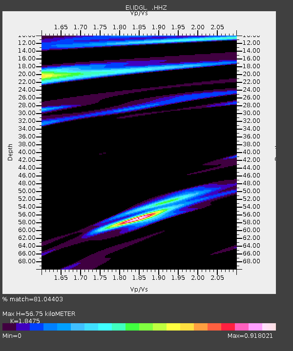
| Estimated Moho Depth: |
56.75 km |
| Estimated Crust Vp/Vs: |
1.85 |
| Assumed Crust Vp: |
6.276 km/s |
| Estimated Crust Vs: |
3.397 km/s |
| Estimated Crust Poisson's Ratio: |
0.29 |
|
| Radial Match: |
81.04403 % |
| Radial Bump: |
400 |
| Transverse Match: |
69.39639 % |
| Transverse Bump: |
400 |
| SOD ConfigId: |
626651 |
| Insert Time: |
2014-04-18 05:42:25.318 +0000 |
| GWidth: |
2.5 |
| Max Bumps: |
400 |
| Tol: |
0.001 |
|

Signal To Noise
| Channel | StoN | STA | LTA |
| EI:IDGL: :HHZ:20130830T16:40:06.140015Z | 2.357355 | 1.6213766E-6 | 6.877948E-7 |
| EI:IDGL: :HHN:20130830T16:40:06.140015Z | 1.8294291 | 5.1809474E-7 | 2.8320022E-7 |
| EI:IDGL: :HHE:20130830T16:40:06.140015Z | 1.6081582 | 5.253073E-7 | 3.266515E-7 |
| Arrivals |
| Ps | 7.9 SECOND |
| PpPs | 25 SECOND |
| PsPs/PpSs | 33 SECOND |


