You are here: Home > Network List > TA - USArray Transportable Network (new EarthScope stations) Stations List
> Station G57A Newington, ON, CAN > Earthquake Result Viewer
G57A Newington, ON, CAN - Earthquake Result Viewer
| Earthquake location: |
Andreanof Islands, Aleutian Is. |
| Earthquake latitude/longitude: |
51.4/-175.2 |
| Earthquake time(UTC): |
2013/08/30 (242) 16:29:05 GMT |
| Earthquake Depth: |
7.3 km |
| Earthquake Magnitude: |
5.5 MB, 4.4 ML |
| Earthquake Catalog/Contributor: |
NEIC PDE/NEIC COMCAT |
|
| Network: |
TA USArray Transportable Network (new EarthScope stations) |
| Station: |
G57A Newington, ON, CAN |
| Lat/Lon: |
45.10 N/74.99 W |
| Elevation: |
96 m |
|
| Distance: |
61.8 deg |
| Az: |
52.246 deg |
| Baz: |
315.651 deg |
| Ray Param: |
0.06062786 |
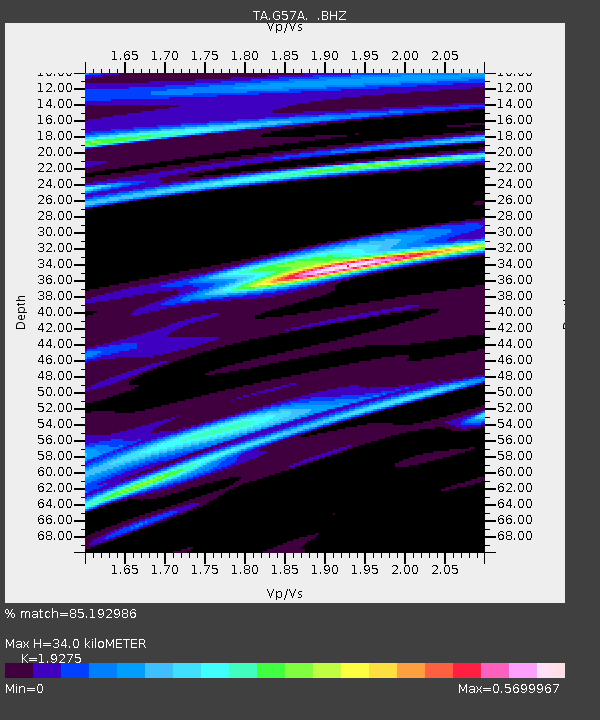
| Estimated Moho Depth: |
34.0 km |
| Estimated Crust Vp/Vs: |
1.93 |
| Assumed Crust Vp: |
6.419 km/s |
| Estimated Crust Vs: |
3.33 km/s |
| Estimated Crust Poisson's Ratio: |
0.32 |
|
| Radial Match: |
85.192986 % |
| Radial Bump: |
400 |
| Transverse Match: |
66.62129 % |
| Transverse Bump: |
400 |
| SOD ConfigId: |
626651 |
| Insert Time: |
2014-04-18 05:51:28.225 +0000 |
| GWidth: |
2.5 |
| Max Bumps: |
400 |
| Tol: |
0.001 |
|
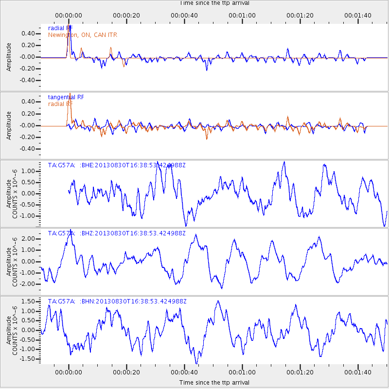
Signal To Noise
| Channel | StoN | STA | LTA |
| TA:G57A: :BHZ:20130830T16:38:53.424988Z | 2.0674932 | 1.6135301E-6 | 7.804283E-7 |
| TA:G57A: :BHN:20130830T16:38:53.424988Z | 2.0476367 | 8.689652E-7 | 4.243747E-7 |
| TA:G57A: :BHE:20130830T16:38:53.424988Z | 2.565865 | 9.672908E-7 | 3.7698427E-7 |
| Arrivals |
| Ps | 5.1 SECOND |
| PpPs | 15 SECOND |
| PsPs/PpSs | 20 SECOND |


