You are here: Home > Network List > TA - USArray Transportable Network (new EarthScope stations) Stations List
> Station Q48A North Vernon, IN, USA > Earthquake Result Viewer
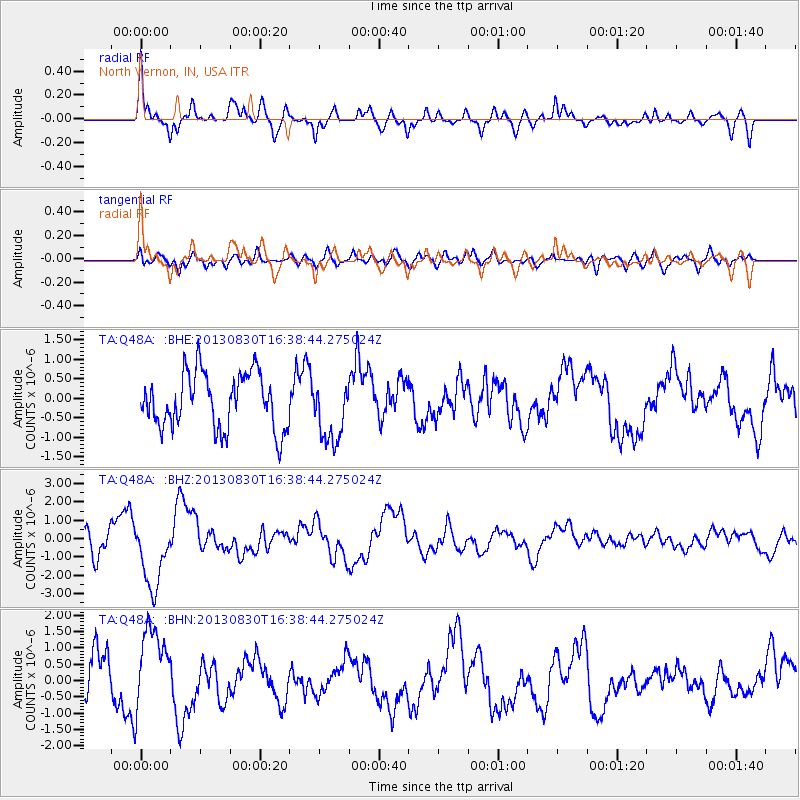
Q48A North Vernon, IN, USA - Earthquake Result Viewer
*The percent match for this event was below the threshold and hence no stack was calculated.
| Earthquake location: |
Andreanof Islands, Aleutian Is. |
| Earthquake latitude/longitude: |
51.4/-175.2 |
| Earthquake time(UTC): |
2013/08/30 (242) 16:29:05 GMT |
| Earthquake Depth: |
7.3 km |
| Earthquake Magnitude: |
5.5 MB, 4.4 ML |
| Earthquake Catalog/Contributor: |
NEIC PDE/NEIC COMCAT |
|
| Network: |
TA USArray Transportable Network (new EarthScope stations) |
| Station: |
Q48A North Vernon, IN, USA |
| Lat/Lon: |
38.93 N/85.73 W |
| Elevation: |
185 m |
|
| Distance: |
60.5 deg |
| Az: |
63.671 deg |
| Baz: |
313.988 deg |
| Ray Param: |
$rayparam |
*The percent match for this event was below the threshold and hence was not used in the summary stack. |
|
| Radial Match: |
78.90068 % |
| Radial Bump: |
393 |
| Transverse Match: |
62.64709 % |
| Transverse Bump: |
400 |
| SOD ConfigId: |
626651 |
| Insert Time: |
2014-04-18 05:53:20.650 +0000 |
| GWidth: |
2.5 |
| Max Bumps: |
400 |
| Tol: |
0.001 |
|
Signal To Noise
| Channel | StoN | STA | LTA |
| TA:Q48A: :BHZ:20130830T16:38:44.275024Z | 1.7360694 | 1.869877E-6 | 1.0770749E-6 |
| TA:Q48A: :BHN:20130830T16:38:44.275024Z | 1.6505338 | 1.2595909E-6 | 7.6314154E-7 |
| TA:Q48A: :BHE:20130830T16:38:44.275024Z | 1.120991 | 7.986765E-7 | 7.1247365E-7 |
| Arrivals |
| Ps | |
| PpPs | |
| PsPs/PpSs | |


