You are here: Home > Network List > UW - Pacific Northwest Regional Seismic Network Stations List
> Station PASS Maple Falls, WA, USA > Earthquake Result Viewer
PASS Maple Falls, WA, USA - Earthquake Result Viewer
| Earthquake location: |
Andreanof Islands, Aleutian Is. |
| Earthquake latitude/longitude: |
51.4/-175.2 |
| Earthquake time(UTC): |
2013/08/30 (242) 16:29:05 GMT |
| Earthquake Depth: |
7.3 km |
| Earthquake Magnitude: |
5.5 MB, 4.4 ML |
| Earthquake Catalog/Contributor: |
NEIC PDE/NEIC COMCAT |
|
| Network: |
UW Pacific Northwest Regional Seismic Network |
| Station: |
PASS Maple Falls, WA, USA |
| Lat/Lon: |
49.00 N/122.09 W |
| Elevation: |
174 m |
|
| Distance: |
33.4 deg |
| Az: |
72.822 deg |
| Baz: |
294.727 deg |
| Ray Param: |
0.07820811 |
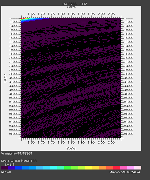
| Estimated Moho Depth: |
10.0 km |
| Estimated Crust Vp/Vs: |
1.60 |
| Assumed Crust Vp: |
6.566 km/s |
| Estimated Crust Vs: |
4.104 km/s |
| Estimated Crust Poisson's Ratio: |
0.18 |
|
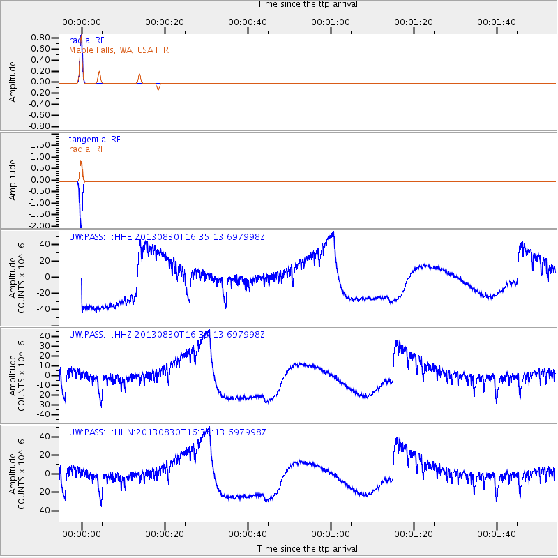
| Radial Match: |
99.98369 % |
| Radial Bump: |
3 |
| Transverse Match: |
99.992455 % |
| Transverse Bump: |
2 |
| SOD ConfigId: |
626651 |
| Insert Time: |
2014-04-18 05:56:37.585 +0000 |
| GWidth: |
2.5 |
| Max Bumps: |
400 |
| Tol: |
0.001 |
|
Signal To Noise
| Channel | StoN | STA | LTA |
| UW:PASS: :HHZ:20130830T16:35:13.697998Z | 0.37087 | 9.579576E-6 | 2.583001E-5 |
| UW:PASS: :HHN:20130830T16:35:13.697998Z | 0.37819567 | 1.0484324E-5 | 2.7721957E-5 |
| UW:PASS: :HHE:20130830T16:35:13.697998Z | 0.3778984 | 1.1479801E-5 | 3.0378009E-5 |
| Arrivals |
| Ps | 1.0 SECOND |
| PpPs | 3.6 SECOND |
| PsPs/PpSs | 4.6 SECOND |


