You are here: Home > Network List > WI - West Indies IPGP Network Stations List
> Station BIM Morne Bigot, Anses d'Arlets, Martinique > Earthquake Result Viewer
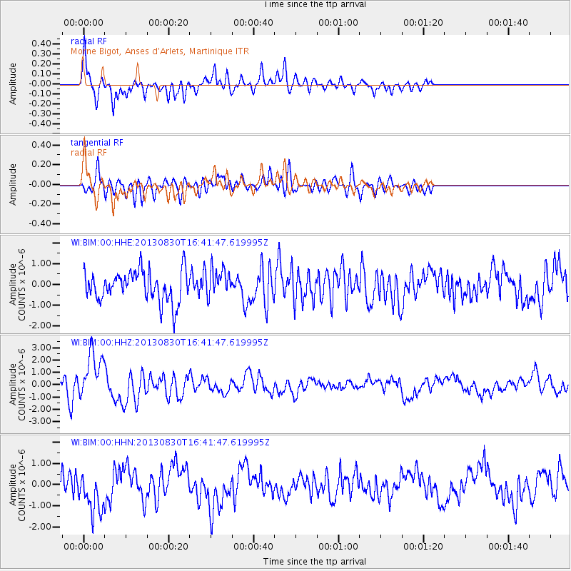
BIM Morne Bigot, Anses d'Arlets, Martinique - Earthquake Result Viewer
*The percent match for this event was below the threshold and hence no stack was calculated.
| Earthquake location: |
Andreanof Islands, Aleutian Is. |
| Earthquake latitude/longitude: |
51.4/-175.2 |
| Earthquake time(UTC): |
2013/08/30 (242) 16:29:05 GMT |
| Earthquake Depth: |
7.3 km |
| Earthquake Magnitude: |
5.5 MB, 4.4 ML |
| Earthquake Catalog/Contributor: |
NEIC PDE/NEIC COMCAT |
|
| Network: |
WI West Indies IPGP Network |
| Station: |
BIM Morne Bigot, Anses d'Arlets, Martinique |
| Lat/Lon: |
14.52 N/61.07 W |
| Elevation: |
391 m |
|
| Distance: |
93.1 deg |
| Az: |
62.282 deg |
| Baz: |
325.088 deg |
| Ray Param: |
$rayparam |
*The percent match for this event was below the threshold and hence was not used in the summary stack. |
|
| Radial Match: |
71.89305 % |
| Radial Bump: |
400 |
| Transverse Match: |
59.756744 % |
| Transverse Bump: |
400 |
| SOD ConfigId: |
626651 |
| Insert Time: |
2014-04-18 05:56:50.522 +0000 |
| GWidth: |
2.5 |
| Max Bumps: |
400 |
| Tol: |
0.001 |
|
Signal To Noise
| Channel | StoN | STA | LTA |
| WI:BIM:00:HHZ:20130830T16:41:47.619995Z | 1.5672907 | 2.0079399E-6 | 1.2811535E-6 |
| WI:BIM:00:HHN:20130830T16:41:47.619995Z | 1.3472873 | 1.0172221E-6 | 7.55015E-7 |
| WI:BIM:00:HHE:20130830T16:41:47.619995Z | 0.9252976 | 6.731856E-7 | 7.2753414E-7 |
| Arrivals |
| Ps | |
| PpPs | |
| PsPs/PpSs | |


