You are here: Home > Network List > IU - Global Seismograph Network (GSN - IRIS/USGS) Stations List
> Station FURI Mt. Furi, Ethiopia > Earthquake Result Viewer
FURI Mt. Furi, Ethiopia - Earthquake Result Viewer

| Earthquake location: |
Yunnan, China |
| Earthquake latitude/longitude: |
28.2/99.4 |
| Earthquake time(UTC): |
2013/08/31 (243) 00:04:17 GMT |
| Earthquake Depth: |
8.0 km |
| Earthquake Magnitude: |
5.6 MWW, 5.5 MWB, 5.6 MWW, 5.7 MWC |
| Earthquake Catalog/Contributor: |
NEIC PDE/NEIC COMCAT |
|
| Network: |
IU Global Seismograph Network (GSN - IRIS/USGS) |
| Station: |
FURI Mt. Furi, Ethiopia |
| Lat/Lon: |
8.90 N/38.68 E |
| Elevation: |
2570 m |
|
| Distance: |
60.0 deg |
| Az: |
263.884 deg |
| Baz: |
62.596 deg |
| Ray Param: |
0.061796635 |
| Estimated Moho Depth: |
14.25 km |
| Estimated Crust Vp/Vs: |
1.60 |
| Assumed Crust Vp: |
6.464 km/s |
| Estimated Crust Vs: |
4.033 km/s |
| Estimated Crust Poisson's Ratio: |
0.18 |
|
| Radial Match: |
80.13289 % |
| Radial Bump: |
400 |
| Transverse Match: |
68.86797 % |
| Transverse Bump: |
400 |
| SOD ConfigId: |
626651 |
| Insert Time: |
2014-04-18 06:06:03.168 +0000 |
| GWidth: |
2.5 |
| Max Bumps: |
400 |
| Tol: |
0.001 |
|
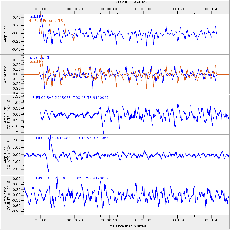
Signal To Noise
| Channel | StoN | STA | LTA |
| IU:FURI:00:BHZ:20130831T00:13:53.919006Z | 5.482845 | 7.8588437E-7 | 1.4333514E-7 |
| IU:FURI:00:BH1:20130831T00:13:53.919006Z | 0.9792243 | 2.2656035E-7 | 2.3136715E-7 |
| IU:FURI:00:BH2:20130831T00:13:53.919006Z | 1.2513926 | 2.2457758E-7 | 1.7946213E-7 |
| Arrivals |
| Ps | 1.4 SECOND |
| PpPs | 5.4 SECOND |
| PsPs/PpSs | 6.8 SECOND |


