You are here: Home > Network List > CI - Caltech Regional Seismic Network Stations List
> Station TIN Tinemaha, Big Pine, CA, USA > Earthquake Result Viewer
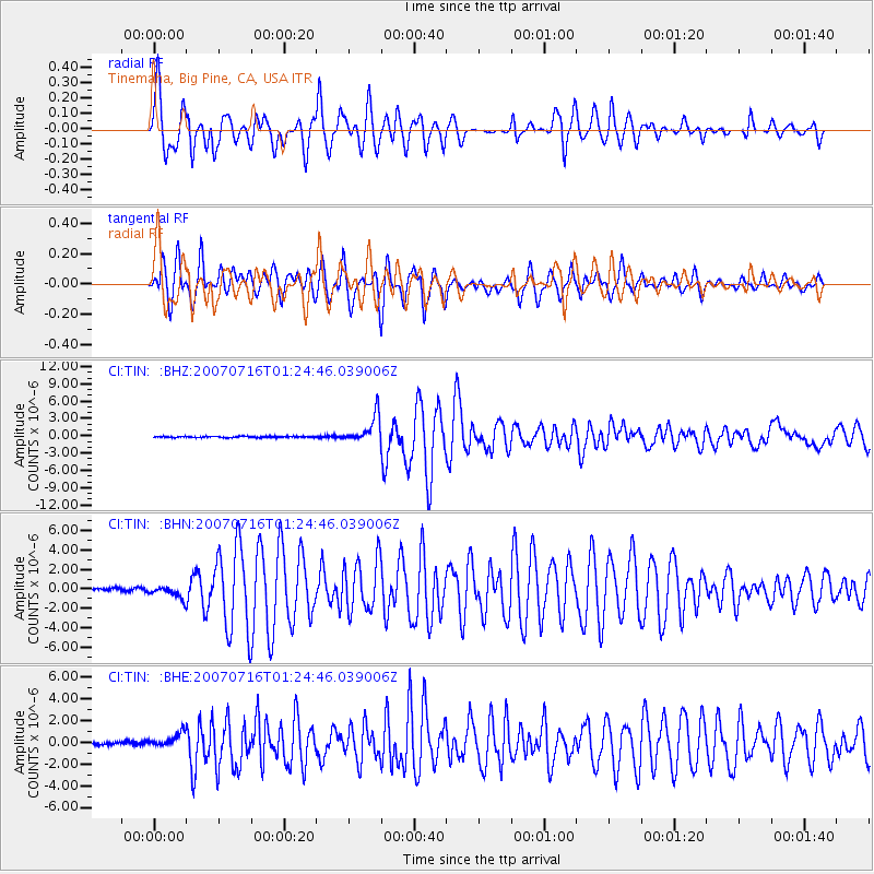
TIN Tinemaha, Big Pine, CA, USA - Earthquake Result Viewer

| Earthquake location: |
Near West Coast Of Honshu, Japan |
| Earthquake latitude/longitude: |
37.5/138.4 |
| Earthquake time(UTC): |
2007/07/16 (197) 01:13:22 GMT |
| Earthquake Depth: |
12 km |
| Earthquake Magnitude: |
6.5 MB, 6.4 MS, 6.6 MW, 6.5 MW |
| Earthquake Catalog/Contributor: |
WHDF/NEIC |
|
| Network: |
CI Caltech Regional Seismic Network |
| Station: |
TIN Tinemaha, Big Pine, CA, USA |
| Lat/Lon: |
37.05 N/118.23 W |
| Elevation: |
1197 m |
|
| Distance: |
77.4 deg |
| Az: |
52.897 deg |
| Baz: |
307.579 deg |
| Ray Param: |
0.050316516 |
| Estimated Moho Depth: |
55.75 km |
| Estimated Crust Vp/Vs: |
1.96 |
| Assumed Crust Vp: |
6.291 km/s |
| Estimated Crust Vs: |
3.218 km/s |
| Estimated Crust Poisson's Ratio: |
0.32 |
|
| Radial Match: |
92.87792 % |
| Radial Bump: |
400 |
| Transverse Match: |
89.524284 % |
| Transverse Bump: |
400 |
| SOD ConfigId: |
2564 |
| Insert Time: |
2010-02-25 20:50:49.358 +0000 |
| GWidth: |
2.5 |
| Max Bumps: |
400 |
| Tol: |
0.001 |
|
Signal To Noise
| Channel | StoN | STA | LTA |
| CI:TIN: :BHN:20070716T01:24:46.039006Z | 3.7341983 | 5.9868427E-7 | 1.6032472E-7 |
| CI:TIN: :BHE:20070716T01:24:46.039006Z | 5.0458865 | 6.4594644E-7 | 1.2801446E-7 |
| CI:TIN: :BHZ:20070716T01:24:46.039006Z | 22.228016 | 2.3555795E-6 | 1.0597344E-7 |
| Arrivals |
| Ps | 8.7 SECOND |
| PpPs | 26 SECOND |
| PsPs/PpSs | 34 SECOND |


