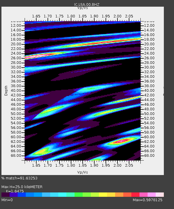
LSA Tibet, China - Earthquake Result Viewer
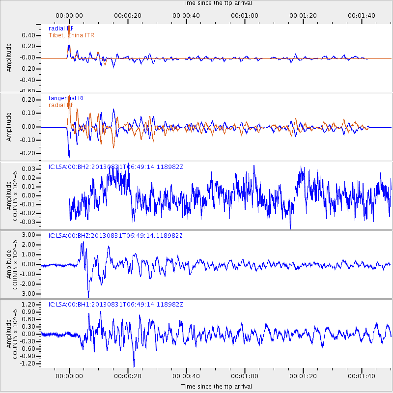
Earthquake location: Andreanof Islands, Aleutian Is.
Earthquake latitude/longitude: 51.2/-174.9
Earthquake time(UTC): 2013/08/31 (243) 06:38:36 GMT
Earthquake Depth: 18 km
Earthquake Magnitude: 6.0 MWW, 5.5 ML, 5.9 MWB, 5.9 MWC, 6.0 MWC, 6.0 MI, 6.0 MWW
Earthquake Catalog/Contributor: NEIC PDE/NEIC COMCAT
Network: IC New China Digital Seismograph Network
Station: LSA Tibet, China
Lat/Lon: 29.70 N/91.13 E
Elevation: 3660 m
Distance: 69.8 deg
Az: 292.319 deg
Baz: 41.945 deg
Ray Param: 0.05541417
Estimated Moho Depth: 25.0 km
Estimated Crust Vp/Vs: 1.65
Assumed Crust Vp: 6.514 km/s
Estimated Crust Vs: 3.954 km/s
Estimated Crust Poisson's Ratio: 0.21
Radial Match: 91.63253 %
Radial Bump: 400
Transverse Match: 91.975975 %
Transverse Bump: 400
SOD ConfigId: 626651
Insert Time: 2014-04-18 06:19:24.235 +0000
GWidth: 2.5
Max Bumps: 400
Tol: 0.001

Signal To Noise

ChannelStoNSTALTA
IC:LSA:00:BHZ:20130831T06:49:14.118982Z12.8722068.170252E-76.3472044E-8
IC:LSA:00:BH1:20130831T06:49:14.118982Z4.25128031.8937374E-74.4545107E-8
IC:LSA:00:BH2:20130831T06:49:14.118982Z0.737315651.1545849E-81.5659303E-8
Arrivals
Ps2.6 SECOND
PpPs9.7 SECOND
PsPs/PpSs12 SECOND