You are here: Home > Network List > TA - USArray Transportable Network (new EarthScope stations) Stations List
> Station 153A Fort Valley, GA, USA > Earthquake Result Viewer
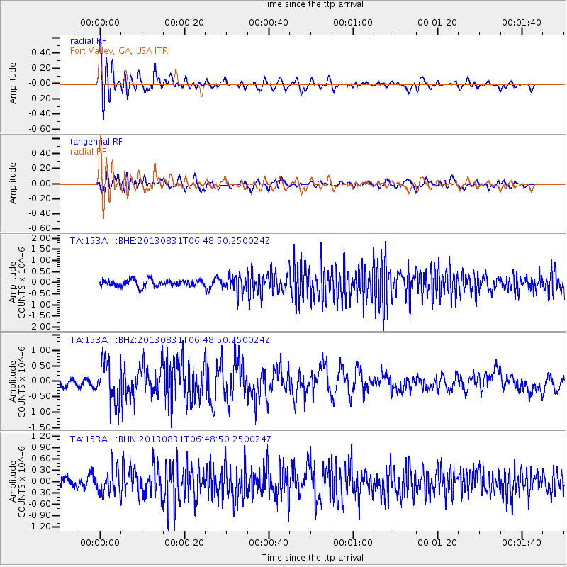
153A Fort Valley, GA, USA - Earthquake Result Viewer
*The percent match for this event was below the threshold and hence no stack was calculated.
| Earthquake location: |
Andreanof Islands, Aleutian Is. |
| Earthquake latitude/longitude: |
51.2/-174.9 |
| Earthquake time(UTC): |
2013/08/31 (243) 06:38:36 GMT |
| Earthquake Depth: |
18 km |
| Earthquake Magnitude: |
6.0 MWW, 5.5 ML, 5.9 MWB, 5.9 MWC, 6.0 MWC, 6.0 MI, 6.0 MWW |
| Earthquake Catalog/Contributor: |
NEIC PDE/NEIC COMCAT |
|
| Network: |
TA USArray Transportable Network (new EarthScope stations) |
| Station: |
153A Fort Valley, GA, USA |
| Lat/Lon: |
32.66 N/83.83 W |
| Elevation: |
160 m |
|
| Distance: |
66.0 deg |
| Az: |
67.442 deg |
| Baz: |
316.509 deg |
| Ray Param: |
$rayparam |
*The percent match for this event was below the threshold and hence was not used in the summary stack. |
|
| Radial Match: |
69.51306 % |
| Radial Bump: |
400 |
| Transverse Match: |
64.07008 % |
| Transverse Bump: |
400 |
| SOD ConfigId: |
626651 |
| Insert Time: |
2014-04-18 06:30:32.978 +0000 |
| GWidth: |
2.5 |
| Max Bumps: |
400 |
| Tol: |
0.001 |
|
Signal To Noise
| Channel | StoN | STA | LTA |
| TA:153A: :BHZ:20130831T06:48:50.250024Z | 6.2739286 | 6.541535E-7 | 1.04265375E-7 |
| TA:153A: :BHN:20130831T06:48:50.250024Z | 2.4201841 | 3.1103485E-7 | 1.2851702E-7 |
| TA:153A: :BHE:20130831T06:48:50.250024Z | 2.3620303 | 3.4721495E-7 | 1.4699852E-7 |
| Arrivals |
| Ps | |
| PpPs | |
| PsPs/PpSs | |


