You are here: Home > Network List > TA - USArray Transportable Network (new EarthScope stations) Stations List
> Station D58A Chemin du LacGrosbois, Trois-Rives, QC, CAN > Earthquake Result Viewer
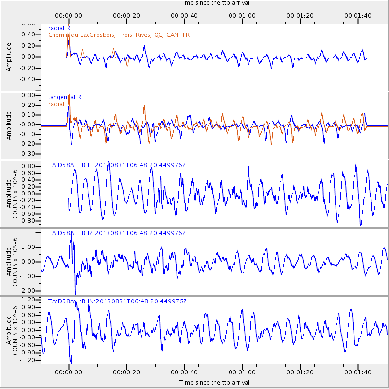
D58A Chemin du LacGrosbois, Trois-Rives, QC, CAN - Earthquake Result Viewer
*The percent match for this event was below the threshold and hence no stack was calculated.
| Earthquake location: |
Andreanof Islands, Aleutian Is. |
| Earthquake latitude/longitude: |
51.2/-174.9 |
| Earthquake time(UTC): |
2013/08/31 (243) 06:38:36 GMT |
| Earthquake Depth: |
18 km |
| Earthquake Magnitude: |
6.0 MWW, 5.5 ML, 5.9 MWB, 5.9 MWC, 6.0 MWC, 6.0 MI, 6.0 MWW |
| Earthquake Catalog/Contributor: |
NEIC PDE/NEIC COMCAT |
|
| Network: |
TA USArray Transportable Network (new EarthScope stations) |
| Station: |
D58A Chemin du LacGrosbois, Trois-Rives, QC, CAN |
| Lat/Lon: |
47.10 N/72.88 W |
| Elevation: |
398 m |
|
| Distance: |
61.4 deg |
| Az: |
49.531 deg |
| Baz: |
315.575 deg |
| Ray Param: |
$rayparam |
*The percent match for this event was below the threshold and hence was not used in the summary stack. |
|
| Radial Match: |
45.572285 % |
| Radial Bump: |
400 |
| Transverse Match: |
48.07255 % |
| Transverse Bump: |
319 |
| SOD ConfigId: |
626651 |
| Insert Time: |
2014-04-18 06:32:15.005 +0000 |
| GWidth: |
2.5 |
| Max Bumps: |
400 |
| Tol: |
0.001 |
|
Signal To Noise
| Channel | StoN | STA | LTA |
| TA:D58A: :BHZ:20130831T06:48:20.449976Z | 2.6929739 | 1.017409E-6 | 3.7780126E-7 |
| TA:D58A: :BHN:20130831T06:48:20.449976Z | 2.3579504 | 7.410695E-7 | 3.1428544E-7 |
| TA:D58A: :BHE:20130831T06:48:20.449976Z | 0.73454267 | 3.0458287E-7 | 4.1465645E-7 |
| Arrivals |
| Ps | |
| PpPs | |
| PsPs/PpSs | |


