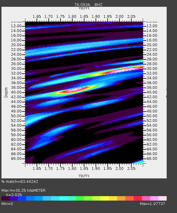
G53A Haliburton, ON, CAN - Earthquake Result Viewer

Earthquake location: Andreanof Islands, Aleutian Is.
Earthquake latitude/longitude: 51.2/-174.9
Earthquake time(UTC): 2013/08/31 (243) 06:38:36 GMT
Earthquake Depth: 18 km
Earthquake Magnitude: 6.0 MWW, 5.5 ML, 5.9 MWB, 5.9 MWC, 6.0 MWC, 6.0 MI, 6.0 MWW
Earthquake Catalog/Contributor: NEIC PDE/NEIC COMCAT
Network: TA USArray Transportable Network (new EarthScope stations)
Station: G53A Haliburton, ON, CAN
Lat/Lon: 45.12 N/78.62 W
Elevation: 333 m
Distance: 60.0 deg
Az: 54.359 deg
Baz: 313.812 deg
Ray Param: 0.061813705
Estimated Moho Depth: 30.25 km
Estimated Crust Vp/Vs: 2.03
Assumed Crust Vp: 6.577 km/s
Estimated Crust Vs: 3.248 km/s
Estimated Crust Poisson's Ratio: 0.34
Radial Match: 83.44242 %
Radial Bump: 356
Transverse Match: 63.427425 %
Transverse Bump: 400
SOD ConfigId: 626651
Insert Time: 2014-04-18 06:33:37.204 +0000
GWidth: 2.5
Max Bumps: 400
Tol: 0.001

Signal To Noise

ChannelStoNSTALTA
TA:G53A: :BHZ:20130831T06:48:10.574976Z11.0685262.2324036E-62.0168932E-7
TA:G53A: :BHN:20130831T06:48:10.574976Z4.33051979.3378685E-72.1562927E-7
TA:G53A: :BHE:20130831T06:48:10.574976Z3.54897578.595419E-72.4219435E-7
Arrivals
Ps4.9 SECOND
PpPs13 SECOND
PsPs/PpSs18 SECOND