You are here: Home > Network List > PF - Volcanologic Network of Piton de Fournaise-OVPF Stations List
> Station GBS Grandes pentes coulee 1943 bas > Earthquake Result Viewer
GBS Grandes pentes coulee 1943 bas - Earthquake Result Viewer
| Earthquake location: |
Northern Molucca Sea |
| Earthquake latitude/longitude: |
1.9/126.5 |
| Earthquake time(UTC): |
2014/11/15 (319) 02:31:40 GMT |
| Earthquake Depth: |
35 km |
| Earthquake Magnitude: |
7.1 MWW, 7.0 MWW, 7.3 MI |
| Earthquake Catalog/Contributor: |
NEIC PDE/NEIC COMCAT |
|
| Network: |
PF Volcanologic Network of Piton de Fournaise-OVPF |
| Station: |
GBS Grandes pentes coulee 1943 bas |
| Lat/Lon: |
21.27 S/55.78 E |
| Elevation: |
471 m |
|
| Distance: |
72.8 deg |
| Az: |
247.167 deg |
| Baz: |
80.973 deg |
| Ray Param: |
0.053342324 |
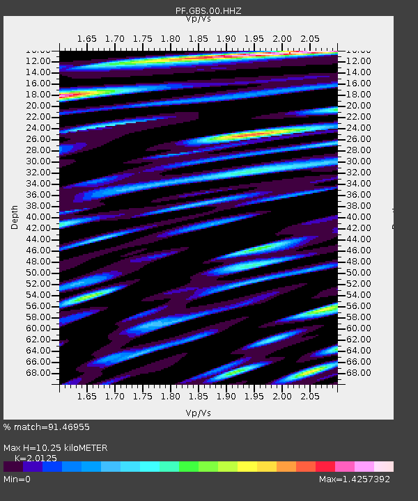
| Estimated Moho Depth: |
10.25 km |
| Estimated Crust Vp/Vs: |
2.01 |
| Assumed Crust Vp: |
4.73 km/s |
| Estimated Crust Vs: |
2.35 km/s |
| Estimated Crust Poisson's Ratio: |
0.34 |
|
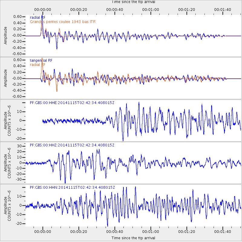
| Radial Match: |
91.46955 % |
| Radial Bump: |
400 |
| Transverse Match: |
84.25535 % |
| Transverse Bump: |
400 |
| SOD ConfigId: |
3390531 |
| Insert Time: |
2019-04-15 00:10:48.752 +0000 |
| GWidth: |
2.5 |
| Max Bumps: |
400 |
| Tol: |
0.001 |
|
Signal To Noise
| Channel | StoN | STA | LTA |
| PF:GBS:00:HHZ:20141115T02:42:34.408015Z | 3.7860317 | 2.9857604E-6 | 7.886253E-7 |
| PF:GBS:00:HHN:20141115T02:42:34.408015Z | 0.8014114 | 1.2034495E-6 | 1.5016627E-6 |
| PF:GBS:00:HHE:20141115T02:42:34.408015Z | 1.2411628 | 1.6818526E-6 | 1.3550622E-6 |
| Arrivals |
| Ps | 2.2 SECOND |
| PpPs | 6.4 SECOND |
| PsPs/PpSs | 8.7 SECOND |


