You are here: Home > Network List > XJ13 - CRAFTI Stations List
> Station KEN4 Ngurumani > Earthquake Result Viewer
KEN4 Ngurumani - Earthquake Result Viewer
| Earthquake location: |
Northern Molucca Sea |
| Earthquake latitude/longitude: |
1.9/126.5 |
| Earthquake time(UTC): |
2014/11/15 (319) 02:31:40 GMT |
| Earthquake Depth: |
35 km |
| Earthquake Magnitude: |
7.1 MWW, 7.0 MWW, 7.3 MI |
| Earthquake Catalog/Contributor: |
NEIC PDE/NEIC COMCAT |
|
| Network: |
XJ CRAFTI |
| Station: |
KEN4 Ngurumani |
| Lat/Lon: |
1.78 S/36.05 E |
| Elevation: |
782 m |
|
| Distance: |
90.6 deg |
| Az: |
268.245 deg |
| Baz: |
88.101 deg |
| Ray Param: |
0.04166088 |
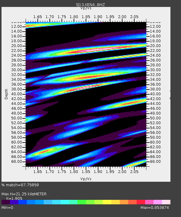
| Estimated Moho Depth: |
21.25 km |
| Estimated Crust Vp/Vs: |
1.90 |
| Assumed Crust Vp: |
6.601 km/s |
| Estimated Crust Vs: |
3.465 km/s |
| Estimated Crust Poisson's Ratio: |
0.31 |
|
| Radial Match: |
87.75959 % |
| Radial Bump: |
400 |
| Transverse Match: |
83.96387 % |
| Transverse Bump: |
400 |
| SOD ConfigId: |
3390531 |
| Insert Time: |
2019-04-15 00:11:21.040 +0000 |
| GWidth: |
2.5 |
| Max Bumps: |
400 |
| Tol: |
0.001 |
|

Signal To Noise
| Channel | StoN | STA | LTA |
| XJ:KEN4: :BHZ:20141115T02:44:07.539973Z | 13.740828 | 1.2225946E-6 | 8.897533E-8 |
| XJ:KEN4: :BHN:20141115T02:44:07.539973Z | 0.68728983 | 6.731087E-8 | 9.793666E-8 |
| XJ:KEN4: :BHE:20141115T02:44:07.539973Z | 5.10398 | 3.90692E-7 | 7.6546534E-8 |
| Arrivals |
| Ps | 3.0 SECOND |
| PpPs | 9.2 SECOND |
| PsPs/PpSs | 12 SECOND |


