You are here: Home > Network List > XJ13 - CRAFTI Stations List
> Station LN14 Matela PS > Earthquake Result Viewer
LN14 Matela PS - Earthquake Result Viewer
| Earthquake location: |
Northern Molucca Sea |
| Earthquake latitude/longitude: |
1.9/126.5 |
| Earthquake time(UTC): |
2014/11/15 (319) 02:31:40 GMT |
| Earthquake Depth: |
35 km |
| Earthquake Magnitude: |
7.1 MWW, 7.0 MWW, 7.3 MI |
| Earthquake Catalog/Contributor: |
NEIC PDE/NEIC COMCAT |
|
| Network: |
XJ CRAFTI |
| Station: |
LN14 Matela PS |
| Lat/Lon: |
2.44 S/36.42 E |
| Elevation: |
1631 m |
|
| Distance: |
90.2 deg |
| Az: |
267.583 deg |
| Baz: |
88.092 deg |
| Ray Param: |
0.041685104 |
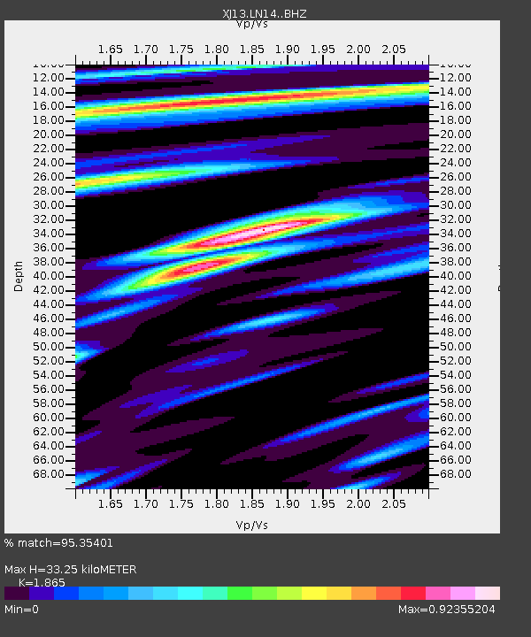
| Estimated Moho Depth: |
33.25 km |
| Estimated Crust Vp/Vs: |
1.87 |
| Assumed Crust Vp: |
6.601 km/s |
| Estimated Crust Vs: |
3.539 km/s |
| Estimated Crust Poisson's Ratio: |
0.30 |
|
| Radial Match: |
95.35401 % |
| Radial Bump: |
314 |
| Transverse Match: |
90.90285 % |
| Transverse Bump: |
400 |
| SOD ConfigId: |
3390531 |
| Insert Time: |
2019-04-15 00:11:23.317 +0000 |
| GWidth: |
2.5 |
| Max Bumps: |
400 |
| Tol: |
0.001 |
|

Signal To Noise
| Channel | StoN | STA | LTA |
| XJ:LN14: :BHZ:20141115T02:44:05.960017Z | 18.609793 | 1.2924263E-6 | 6.9448724E-8 |
| XJ:LN14: :BHN:20141115T02:44:05.960017Z | 0.8174538 | 6.116253E-8 | 7.482078E-8 |
| XJ:LN14: :BHE:20141115T02:44:05.960017Z | 4.46211 | 4.221227E-7 | 9.460159E-8 |
| Arrivals |
| Ps | 4.4 SECOND |
| PpPs | 14 SECOND |
| PsPs/PpSs | 19 SECOND |


