You are here: Home > Network List > XJ13 - CRAFTI Stations List
> Station PR11 Kitumbeine SS > Earthquake Result Viewer
PR11 Kitumbeine SS - Earthquake Result Viewer
| Earthquake location: |
Northern Molucca Sea |
| Earthquake latitude/longitude: |
1.9/126.5 |
| Earthquake time(UTC): |
2014/11/15 (319) 02:31:40 GMT |
| Earthquake Depth: |
35 km |
| Earthquake Magnitude: |
7.1 MWW, 7.0 MWW, 7.3 MI |
| Earthquake Catalog/Contributor: |
NEIC PDE/NEIC COMCAT |
|
| Network: |
XJ CRAFTI |
| Station: |
PR11 Kitumbeine SS |
| Lat/Lon: |
2.82 S/36.30 E |
| Elevation: |
1265 m |
|
| Distance: |
90.3 deg |
| Az: |
267.206 deg |
| Baz: |
88.099 deg |
| Ray Param: |
0.04167592 |
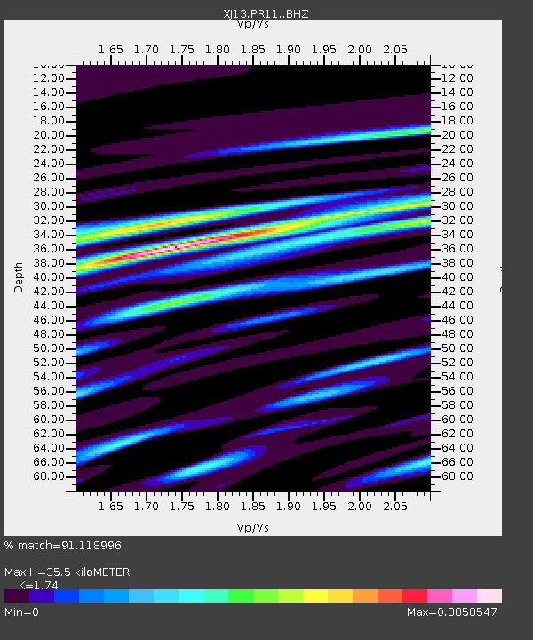
| Estimated Moho Depth: |
35.5 km |
| Estimated Crust Vp/Vs: |
1.74 |
| Assumed Crust Vp: |
6.601 km/s |
| Estimated Crust Vs: |
3.793 km/s |
| Estimated Crust Poisson's Ratio: |
0.25 |
|
| Radial Match: |
91.118996 % |
| Radial Bump: |
400 |
| Transverse Match: |
89.110664 % |
| Transverse Bump: |
400 |
| SOD ConfigId: |
3390531 |
| Insert Time: |
2019-04-15 00:11:31.058 +0000 |
| GWidth: |
2.5 |
| Max Bumps: |
400 |
| Tol: |
0.001 |
|

Signal To Noise
| Channel | StoN | STA | LTA |
| XJ:PR11: :BHZ:20141115T02:44:06.559993Z | 23.207045 | 1.5375095E-6 | 6.625184E-8 |
| XJ:PR11: :BHN:20141115T02:44:06.559993Z | 0.63677466 | 6.7917696E-8 | 1.0665892E-7 |
| XJ:PR11: :BHE:20141115T02:44:06.559993Z | 5.9170213 | 6.329541E-7 | 1.0697174E-7 |
| Arrivals |
| Ps | 4.1 SECOND |
| PpPs | 14 SECOND |
| PsPs/PpSs | 18 SECOND |


