You are here: Home > Network List > XJ13 - CRAFTI Stations List
> Station NG56 Ngoile bomas > Earthquake Result Viewer
NG56 Ngoile bomas - Earthquake Result Viewer
| Earthquake location: |
Northern Molucca Sea |
| Earthquake latitude/longitude: |
1.9/126.5 |
| Earthquake time(UTC): |
2014/11/15 (319) 02:31:40 GMT |
| Earthquake Depth: |
35 km |
| Earthquake Magnitude: |
7.1 MWW, 7.0 MWW, 7.3 MI |
| Earthquake Catalog/Contributor: |
NEIC PDE/NEIC COMCAT |
|
| Network: |
XJ CRAFTI |
| Station: |
NG56 Ngoile bomas |
| Lat/Lon: |
3.10 S/35.41 E |
| Elevation: |
1505 m |
|
| Distance: |
91.2 deg |
| Az: |
266.964 deg |
| Baz: |
88.148 deg |
| Ray Param: |
0.0416119 |
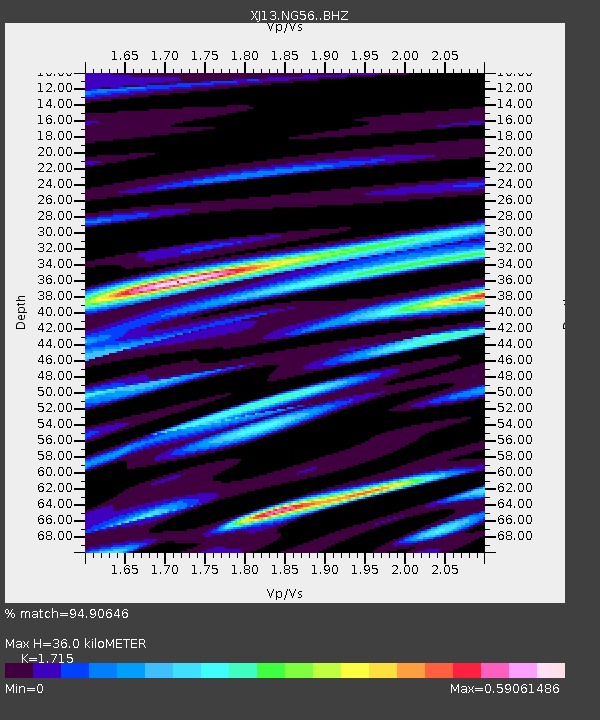
| Estimated Moho Depth: |
36.0 km |
| Estimated Crust Vp/Vs: |
1.72 |
| Assumed Crust Vp: |
6.576 km/s |
| Estimated Crust Vs: |
3.835 km/s |
| Estimated Crust Poisson's Ratio: |
0.24 |
|
| Radial Match: |
94.90646 % |
| Radial Bump: |
400 |
| Transverse Match: |
90.73547 % |
| Transverse Bump: |
400 |
| SOD ConfigId: |
3390531 |
| Insert Time: |
2019-04-15 00:11:31.386 +0000 |
| GWidth: |
2.5 |
| Max Bumps: |
400 |
| Tol: |
0.001 |
|

Signal To Noise
| Channel | StoN | STA | LTA |
| XJ:NG56: :BHZ:20141115T02:44:10.700007Z | 8.97281 | 1.0452391E-6 | 1.1648961E-7 |
| XJ:NG56: :BHN:20141115T02:44:10.700007Z | 1.1136019 | 1.9678824E-7 | 1.7671329E-7 |
| XJ:NG56: :BHE:20141115T02:44:10.700007Z | 4.3683076 | 4.215424E-7 | 9.650017E-8 |
| Arrivals |
| Ps | 4.0 SECOND |
| PpPs | 15 SECOND |
| PsPs/PpSs | 19 SECOND |


