You are here: Home > Network List > XJ13 - CRAFTI Stations List
> Station PR61 Kiloki Boma > Earthquake Result Viewer
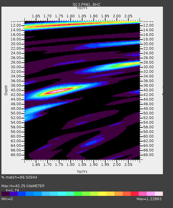
PR61 Kiloki Boma - Earthquake Result Viewer
| Earthquake location: |
Northern Molucca Sea |
| Earthquake latitude/longitude: |
1.9/126.5 |
| Earthquake time(UTC): |
2014/11/15 (319) 02:31:40 GMT |
| Earthquake Depth: |
35 km |
| Earthquake Magnitude: |
7.1 MWW, 7.0 MWW, 7.3 MI |
| Earthquake Catalog/Contributor: |
NEIC PDE/NEIC COMCAT |
|
| Network: |
XJ CRAFTI |
| Station: |
PR61 Kiloki Boma |
| Lat/Lon: |
2.96 S/35.25 E |
| Elevation: |
1549 m |
|
| Distance: |
91.4 deg |
| Az: |
267.105 deg |
| Baz: |
88.153 deg |
| Ray Param: |
0.041600768 |
| Estimated Moho Depth: |
40.25 km |
| Estimated Crust Vp/Vs: |
1.74 |
| Assumed Crust Vp: |
6.576 km/s |
| Estimated Crust Vs: |
3.779 km/s |
| Estimated Crust Poisson's Ratio: |
0.25 |
|
| Radial Match: |
96.50844 % |
| Radial Bump: |
343 |
| Transverse Match: |
87.709564 % |
| Transverse Bump: |
400 |
| SOD ConfigId: |
3390531 |
| Insert Time: |
2019-04-15 00:11:35.215 +0000 |
| GWidth: |
2.5 |
| Max Bumps: |
400 |
| Tol: |
0.001 |
|

Signal To Noise
| Channel | StoN | STA | LTA |
| XJ:PR61: :BHZ:20141115T02:44:11.419978Z | 13.910033 | 1.0727415E-6 | 7.711998E-8 |
| XJ:PR61: :BHN:20141115T02:44:11.419978Z | 0.4438832 | 8.0454214E-8 | 1.8125085E-7 |
| XJ:PR61: :BHE:20141115T02:44:11.419978Z | 4.1225915 | 3.081433E-7 | 7.474505E-8 |
| Arrivals |
| Ps | 4.6 SECOND |
| PpPs | 16 SECOND |
| PsPs/PpSs | 21 SECOND |


