You are here: Home > Network List > XJ13 - CRAFTI Stations List
> Station PR62 Oldupai Boma > Earthquake Result Viewer
PR62 Oldupai Boma - Earthquake Result Viewer
| Earthquake location: |
Northern Molucca Sea |
| Earthquake latitude/longitude: |
1.9/126.5 |
| Earthquake time(UTC): |
2014/11/15 (319) 02:31:40 GMT |
| Earthquake Depth: |
35 km |
| Earthquake Magnitude: |
7.1 MWW, 7.0 MWW, 7.3 MI |
| Earthquake Catalog/Contributor: |
NEIC PDE/NEIC COMCAT |
|
| Network: |
XJ CRAFTI |
| Station: |
PR62 Oldupai Boma |
| Lat/Lon: |
2.98 S/35.37 E |
| Elevation: |
1454 m |
|
| Distance: |
91.3 deg |
| Az: |
267.077 deg |
| Baz: |
88.147 deg |
| Ray Param: |
0.041609667 |
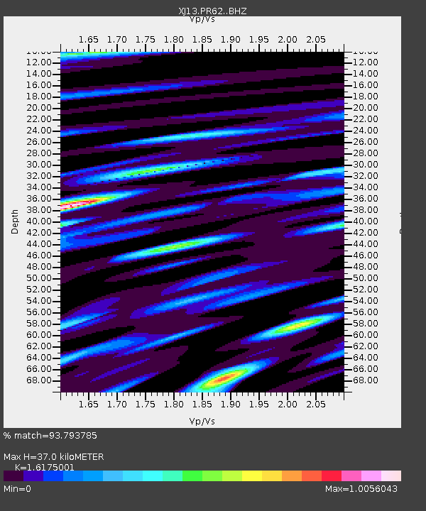
| Estimated Moho Depth: |
37.0 km |
| Estimated Crust Vp/Vs: |
1.62 |
| Assumed Crust Vp: |
6.576 km/s |
| Estimated Crust Vs: |
4.066 km/s |
| Estimated Crust Poisson's Ratio: |
0.19 |
|
| Radial Match: |
93.793785 % |
| Radial Bump: |
400 |
| Transverse Match: |
85.64996 % |
| Transverse Bump: |
400 |
| SOD ConfigId: |
3390531 |
| Insert Time: |
2019-04-15 00:11:35.638 +0000 |
| GWidth: |
2.5 |
| Max Bumps: |
400 |
| Tol: |
0.001 |
|

Signal To Noise
| Channel | StoN | STA | LTA |
| XJ:PR62: :BHZ:20141115T02:44:10.85998Z | 5.986234 | 7.8967577E-7 | 1.3191529E-7 |
| XJ:PR62: :BHN:20141115T02:44:10.85998Z | 0.95718884 | 1.17838546E-7 | 1.2310898E-7 |
| XJ:PR62: :BHE:20141115T02:44:10.85998Z | 1.6362339 | 2.1450502E-7 | 1.310968E-7 |
| Arrivals |
| Ps | 3.6 SECOND |
| PpPs | 14 SECOND |
| PsPs/PpSs | 18 SECOND |


