You are here: Home > Network List > YB13 - Continental Dynamics/Cent. Anatolian Tectonics:Surface to Mantle Dynamics During Stations List
> Station AT06 Campinar,Yozgat,Turkey > Earthquake Result Viewer
AT06 Campinar,Yozgat,Turkey - Earthquake Result Viewer
| Earthquake location: |
Northern Molucca Sea |
| Earthquake latitude/longitude: |
1.9/126.5 |
| Earthquake time(UTC): |
2014/11/15 (319) 02:31:40 GMT |
| Earthquake Depth: |
35 km |
| Earthquake Magnitude: |
7.1 MWW, 7.0 MWW, 7.3 MI |
| Earthquake Catalog/Contributor: |
NEIC PDE/NEIC COMCAT |
|
| Network: |
YB Continental Dynamics/Cent. Anatolian Tectonics:Surface to Mantle Dynamics During |
| Station: |
AT06 Campinar,Yozgat,Turkey |
| Lat/Lon: |
39.67 N/35.67 E |
| Elevation: |
1338 m |
|
| Distance: |
89.5 deg |
| Az: |
309.489 deg |
| Baz: |
87.962 deg |
| Ray Param: |
0.041788347 |
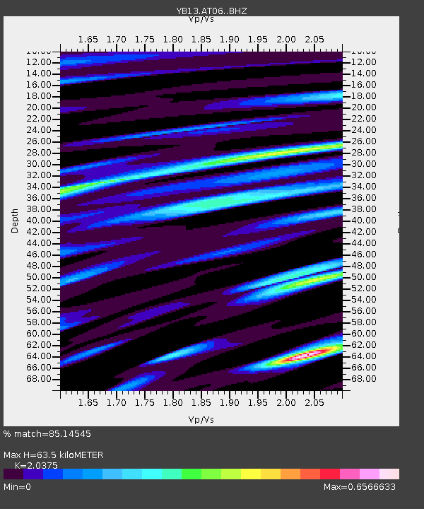
| Estimated Moho Depth: |
63.5 km |
| Estimated Crust Vp/Vs: |
2.04 |
| Assumed Crust Vp: |
6.35 km/s |
| Estimated Crust Vs: |
3.117 km/s |
| Estimated Crust Poisson's Ratio: |
0.34 |
|
| Radial Match: |
85.14545 % |
| Radial Bump: |
400 |
| Transverse Match: |
81.138504 % |
| Transverse Bump: |
400 |
| SOD ConfigId: |
3390531 |
| Insert Time: |
2019-04-15 00:12:10.213 +0000 |
| GWidth: |
2.5 |
| Max Bumps: |
400 |
| Tol: |
0.001 |
|

Signal To Noise
| Channel | StoN | STA | LTA |
| YB:AT06: :BHZ:20141115T02:44:02.85998Z | 28.533743 | 2.0581156E-6 | 7.212918E-8 |
| YB:AT06: :BHN:20141115T02:44:02.85998Z | 3.3856983 | 1.8702926E-7 | 5.5240967E-8 |
| YB:AT06: :BHE:20141115T02:44:02.85998Z | 10.132347 | 5.694072E-7 | 5.6196967E-8 |
| Arrivals |
| Ps | 11 SECOND |
| PpPs | 30 SECOND |
| PsPs/PpSs | 40 SECOND |


