You are here: Home > Network List > TA - USArray Transportable Network (new EarthScope stations) Stations List
> Station S54A Dingess, Beckley, WV, USA > Earthquake Result Viewer
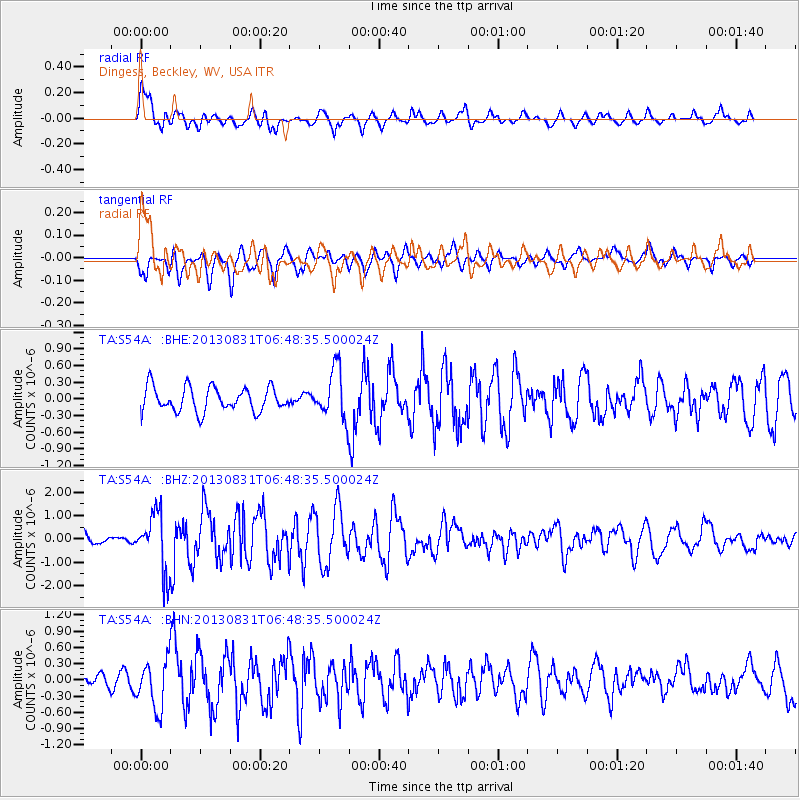
S54A Dingess, Beckley, WV, USA - Earthquake Result Viewer
*The percent match for this event was below the threshold and hence no stack was calculated.
| Earthquake location: |
Andreanof Islands, Aleutian Is. |
| Earthquake latitude/longitude: |
51.2/-174.9 |
| Earthquake time(UTC): |
2013/08/31 (243) 06:38:36 GMT |
| Earthquake Depth: |
18 km |
| Earthquake Magnitude: |
6.0 MWW, 5.5 ML, 5.9 MWB, 5.9 MWC, 6.0 MWC, 6.0 MI, 6.0 MWW |
| Earthquake Catalog/Contributor: |
NEIC PDE/NEIC COMCAT |
|
| Network: |
TA USArray Transportable Network (new EarthScope stations) |
| Station: |
S54A Dingess, Beckley, WV, USA |
| Lat/Lon: |
37.80 N/81.31 W |
| Elevation: |
636 m |
|
| Distance: |
63.7 deg |
| Az: |
61.869 deg |
| Baz: |
315.586 deg |
| Ray Param: |
$rayparam |
*The percent match for this event was below the threshold and hence was not used in the summary stack. |
|
| Radial Match: |
65.96116 % |
| Radial Bump: |
400 |
| Transverse Match: |
66.9727 % |
| Transverse Bump: |
400 |
| SOD ConfigId: |
626651 |
| Insert Time: |
2014-04-18 06:40:37.269 +0000 |
| GWidth: |
2.5 |
| Max Bumps: |
400 |
| Tol: |
0.001 |
|
Signal To Noise
| Channel | StoN | STA | LTA |
| TA:S54A: :BHZ:20130831T06:48:35.500024Z | 3.7035246 | 1.2661944E-6 | 3.4188903E-7 |
| TA:S54A: :BHN:20130831T06:48:35.500024Z | 2.3332546 | 4.4671575E-7 | 1.9145607E-7 |
| TA:S54A: :BHE:20130831T06:48:35.500024Z | 2.085303 | 4.537734E-7 | 2.1760549E-7 |
| Arrivals |
| Ps | |
| PpPs | |
| PsPs/PpSs | |


