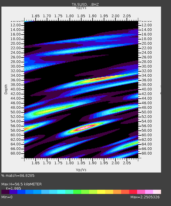
SUSD Miller, SD, USA - Earthquake Result Viewer

Earthquake location: Andreanof Islands, Aleutian Is.
Earthquake latitude/longitude: 51.2/-174.9
Earthquake time(UTC): 2013/08/31 (243) 06:38:36 GMT
Earthquake Depth: 18 km
Earthquake Magnitude: 6.0 MWW, 5.5 ML, 5.9 MWB, 5.9 MWC, 6.0 MWC, 6.0 MI, 6.0 MWW
Earthquake Catalog/Contributor: NEIC PDE/NEIC COMCAT
Network: TA USArray Transportable Network (new EarthScope stations)
Station: SUSD Miller, SD, USA
Lat/Lon: 44.44 N/98.96 W
Elevation: 520 m
Distance: 49.3 deg
Az: 66.391 deg
Baz: 306.47 deg
Ray Param: 0.06875009
Estimated Moho Depth: 56.5 km
Estimated Crust Vp/Vs: 1.87
Assumed Crust Vp: 6.53 km/s
Estimated Crust Vs: 3.502 km/s
Estimated Crust Poisson's Ratio: 0.30
Radial Match: 86.8285 %
Radial Bump: 400
Transverse Match: 68.49687 %
Transverse Bump: 400
SOD ConfigId: 626651
Insert Time: 2014-04-18 06:40:59.915 +0000
GWidth: 2.5
Max Bumps: 400
Tol: 0.001

Signal To Noise

ChannelStoNSTALTA
TA:SUSD: :BHZ:20130831T06:46:53.450006Z7.839021.4055641E-61.7930356E-7
TA:SUSD: :BHN:20130831T06:46:53.450006Z1.32707734.9492826E-73.729461E-7
TA:SUSD: :BHE:20130831T06:46:53.450006Z3.5364437.615291E-72.153376E-7
Arrivals
Ps7.9 SECOND
PpPs23 SECOND
PsPs/PpSs31 SECOND