TPFO Pinon Flats, CA, USA - Earthquake Result Viewer
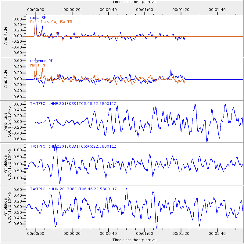
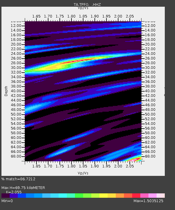
Earthquake location: Andreanof Islands, Aleutian Is.
Earthquake latitude/longitude: 51.2/-174.9
Earthquake time(UTC): 2013/08/31 (243) 06:38:36 GMT
Earthquake Depth: 18 km
Earthquake Magnitude: 6.0 MWW, 5.5 ML, 5.9 MWB, 5.9 MWC, 6.0 MWC, 6.0 MI, 6.0 MWW
Earthquake Catalog/Contributor: NEIC PDE/NEIC COMCAT
Network: TA USArray Transportable Network (new EarthScope stations)
Station: TPFO Pinon Flats, CA, USA
Lat/Lon: 33.61 N/116.45 W
Elevation: 1275 m
Distance: 45.4 deg
Az: 89.431 deg
Baz: 311.13 deg
Ray Param: 0.071308814
Estimated Moho Depth: 69.75 km
Estimated Crust Vp/Vs: 2.06
Assumed Crust Vp: 6.264 km/s
Estimated Crust Vs: 3.048 km/s
Estimated Crust Poisson's Ratio: 0.34
Radial Match: 86.7212 %
Radial Bump: 305
Transverse Match: 72.43403 %
Transverse Bump: 400
SOD ConfigId: 626651
Insert Time: 2014-04-18 06:41:36.096 +0000
GWidth: 2.5
Max Bumps: 400
Tol: 0.001

Signal To Noise

ChannelStoNSTALTA
TA:TPFO: :HHZ:20130831T06:46:22.580011Z1.63624642.3834343E-71.4566476E-7
TA:TPFO: :HHN:20130831T06:46:22.580011Z1.51915241.3560249E-78.9261945E-8
TA:TPFO: :HHE:20130831T06:46:22.580011Z2.71171432.0718885E-77.6405115E-8
Arrivals
Ps12 SECOND
PpPs32 SECOND
PsPs/PpSs45 SECOND