You are here: Home > Network List > TA - USArray Transportable Network (new EarthScope stations) Stations List
> Station U52A Thorn Hill, TN, USA > Earthquake Result Viewer
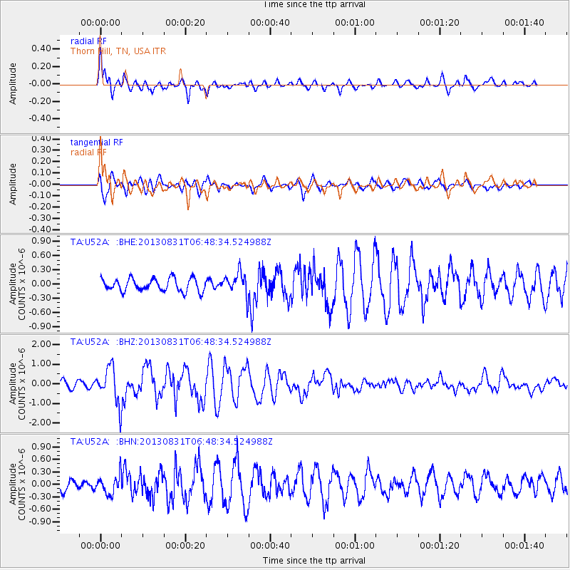
U52A Thorn Hill, TN, USA - Earthquake Result Viewer
*The percent match for this event was below the threshold and hence no stack was calculated.
| Earthquake location: |
Andreanof Islands, Aleutian Is. |
| Earthquake latitude/longitude: |
51.2/-174.9 |
| Earthquake time(UTC): |
2013/08/31 (243) 06:38:36 GMT |
| Earthquake Depth: |
18 km |
| Earthquake Magnitude: |
6.0 MWW, 5.5 ML, 5.9 MWB, 5.9 MWC, 6.0 MWC, 6.0 MI, 6.0 MWW |
| Earthquake Catalog/Contributor: |
NEIC PDE/NEIC COMCAT |
|
| Network: |
TA USArray Transportable Network (new EarthScope stations) |
| Station: |
U52A Thorn Hill, TN, USA |
| Lat/Lon: |
36.39 N/83.37 W |
| Elevation: |
510 m |
|
| Distance: |
63.5 deg |
| Az: |
64.276 deg |
| Baz: |
315.42 deg |
| Ray Param: |
$rayparam |
*The percent match for this event was below the threshold and hence was not used in the summary stack. |
|
| Radial Match: |
73.573 % |
| Radial Bump: |
400 |
| Transverse Match: |
66.79347 % |
| Transverse Bump: |
400 |
| SOD ConfigId: |
626651 |
| Insert Time: |
2014-04-18 06:41:49.576 +0000 |
| GWidth: |
2.5 |
| Max Bumps: |
400 |
| Tol: |
0.001 |
|
Signal To Noise
| Channel | StoN | STA | LTA |
| TA:U52A: :BHZ:20130831T06:48:34.524988Z | 5.11399 | 9.457041E-7 | 1.849249E-7 |
| TA:U52A: :BHN:20130831T06:48:34.524988Z | 1.1154213 | 2.3488202E-7 | 2.1057696E-7 |
| TA:U52A: :BHE:20130831T06:48:34.524988Z | 1.8735037 | 2.5002768E-7 | 1.334546E-7 |
| Arrivals |
| Ps | |
| PpPs | |
| PsPs/PpSs | |


