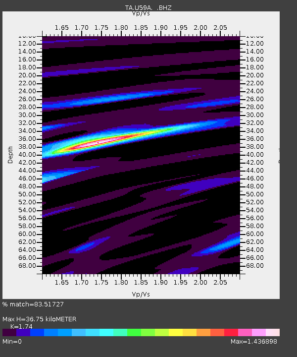
U59A Littleton, NC, USA - Earthquake Result Viewer
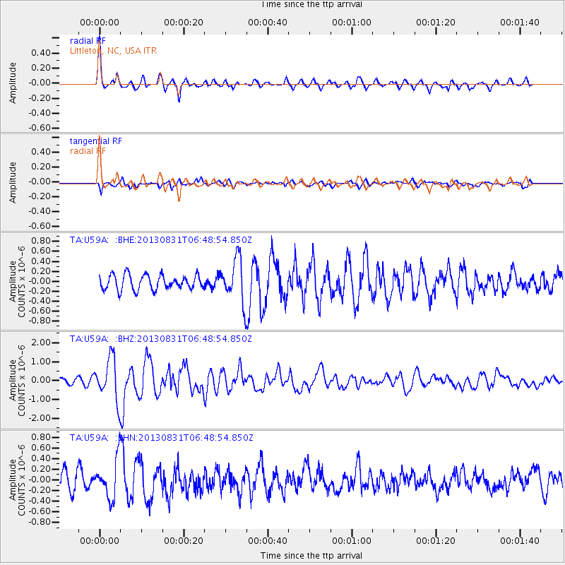
Earthquake location: Andreanof Islands, Aleutian Is.
Earthquake latitude/longitude: 51.2/-174.9
Earthquake time(UTC): 2013/08/31 (243) 06:38:36 GMT
Earthquake Depth: 18 km
Earthquake Magnitude: 6.0 MWW, 5.5 ML, 5.9 MWB, 5.9 MWC, 6.0 MWC, 6.0 MI, 6.0 MWW
Earthquake Catalog/Contributor: NEIC PDE/NEIC COMCAT
Network: TA USArray Transportable Network (new EarthScope stations)
Station: U59A Littleton, NC, USA
Lat/Lon: 36.35 N/77.79 W
Elevation: 99 m
Distance: 66.7 deg
Az: 60.72 deg
Baz: 317.217 deg
Ray Param: 0.05743697
Estimated Moho Depth: 36.75 km
Estimated Crust Vp/Vs: 1.74
Assumed Crust Vp: 6.565 km/s
Estimated Crust Vs: 3.773 km/s
Estimated Crust Poisson's Ratio: 0.25
Radial Match: 83.51727 %
Radial Bump: 400
Transverse Match: 66.41648 %
Transverse Bump: 400
SOD ConfigId: 626651
Insert Time: 2014-04-18 06:42:04.535 +0000
GWidth: 2.5
Max Bumps: 400
Tol: 0.001

Signal To Noise

ChannelStoNSTALTA
TA:U59A: :BHZ:20130831T06:48:54.850Z6.56867841.1443698E-61.7421614E-7
TA:U59A: :BHN:20130831T06:48:54.850Z2.76817083.833881E-71.3849872E-7
TA:U59A: :BHE:20130831T06:48:54.850Z3.0793554.5087646E-71.4641913E-7
Arrivals
Ps4.3 SECOND
PpPs15 SECOND
PsPs/PpSs19 SECOND