You are here: Home > Network List > YB13 - Continental Dynamics/Cent. Anatolian Tectonics:Surface to Mantle Dynamics During Stations List
> Station AT46 Hacihaslani,Adana,Turkey > Earthquake Result Viewer
AT46 Hacihaslani,Adana,Turkey - Earthquake Result Viewer
| Earthquake location: |
Northern Molucca Sea |
| Earthquake latitude/longitude: |
1.9/126.5 |
| Earthquake time(UTC): |
2014/11/15 (319) 02:31:40 GMT |
| Earthquake Depth: |
35 km |
| Earthquake Magnitude: |
7.1 MWW, 7.0 MWW, 7.3 MI |
| Earthquake Catalog/Contributor: |
NEIC PDE/NEIC COMCAT |
|
| Network: |
YB Continental Dynamics/Cent. Anatolian Tectonics:Surface to Mantle Dynamics During |
| Station: |
AT46 Hacihaslani,Adana,Turkey |
| Lat/Lon: |
37.30 N/35.58 E |
| Elevation: |
220 m |
|
| Distance: |
89.6 deg |
| Az: |
307.127 deg |
| Baz: |
87.887 deg |
| Ray Param: |
0.04172749 |
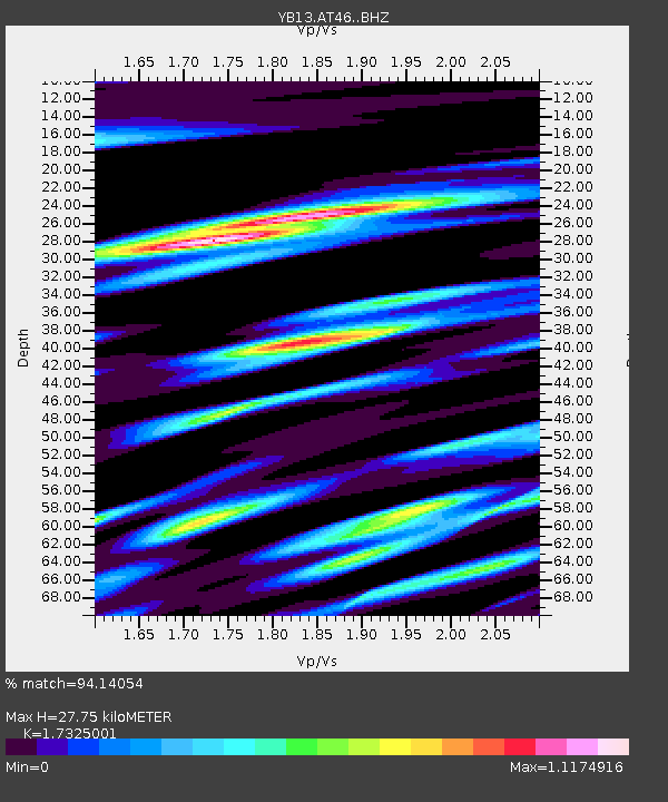
| Estimated Moho Depth: |
27.75 km |
| Estimated Crust Vp/Vs: |
1.73 |
| Assumed Crust Vp: |
6.247 km/s |
| Estimated Crust Vs: |
3.605 km/s |
| Estimated Crust Poisson's Ratio: |
0.25 |
|
| Radial Match: |
94.14054 % |
| Radial Bump: |
344 |
| Transverse Match: |
87.67643 % |
| Transverse Bump: |
391 |
| SOD ConfigId: |
3390531 |
| Insert Time: |
2019-04-15 00:12:35.655 +0000 |
| GWidth: |
2.5 |
| Max Bumps: |
400 |
| Tol: |
0.001 |
|

Signal To Noise
| Channel | StoN | STA | LTA |
| YB:AT46: :BHZ:20141115T02:44:03.559993Z | 12.83853 | 2.1468636E-6 | 1.6722036E-7 |
| YB:AT46: :BHN:20141115T02:44:03.559993Z | 0.8882075 | 1.3339644E-7 | 1.5018612E-7 |
| YB:AT46: :BHE:20141115T02:44:03.559993Z | 3.0154326 | 6.927095E-7 | 2.2972142E-7 |
| Arrivals |
| Ps | 3.3 SECOND |
| PpPs | 12 SECOND |
| PsPs/PpSs | 15 SECOND |


