You are here: Home > Network List > TA - USArray Transportable Network (new EarthScope stations) Stations List
> Station V56A Mocksville, NC, USA > Earthquake Result Viewer
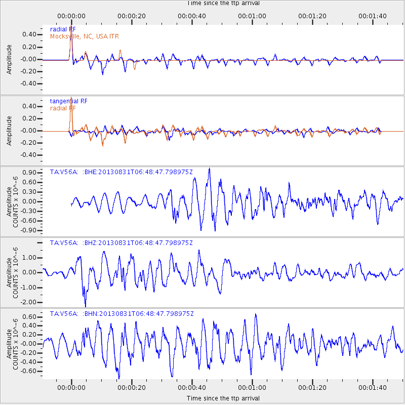
V56A Mocksville, NC, USA - Earthquake Result Viewer
*The percent match for this event was below the threshold and hence no stack was calculated.
| Earthquake location: |
Andreanof Islands, Aleutian Is. |
| Earthquake latitude/longitude: |
51.2/-174.9 |
| Earthquake time(UTC): |
2013/08/31 (243) 06:38:36 GMT |
| Earthquake Depth: |
18 km |
| Earthquake Magnitude: |
6.0 MWW, 5.5 ML, 5.9 MWB, 5.9 MWC, 6.0 MWC, 6.0 MI, 6.0 MWW |
| Earthquake Catalog/Contributor: |
NEIC PDE/NEIC COMCAT |
|
| Network: |
TA USArray Transportable Network (new EarthScope stations) |
| Station: |
V56A Mocksville, NC, USA |
| Lat/Lon: |
35.81 N/80.50 W |
| Elevation: |
237 m |
|
| Distance: |
65.6 deg |
| Az: |
62.873 deg |
| Baz: |
316.502 deg |
| Ray Param: |
$rayparam |
*The percent match for this event was below the threshold and hence was not used in the summary stack. |
|
| Radial Match: |
79.24294 % |
| Radial Bump: |
367 |
| Transverse Match: |
65.79291 % |
| Transverse Bump: |
400 |
| SOD ConfigId: |
626651 |
| Insert Time: |
2014-04-18 06:42:30.172 +0000 |
| GWidth: |
2.5 |
| Max Bumps: |
400 |
| Tol: |
0.001 |
|
Signal To Noise
| Channel | StoN | STA | LTA |
| TA:V56A: :BHZ:20130831T06:48:47.798975Z | 4.829134 | 9.283983E-7 | 1.9224943E-7 |
| TA:V56A: :BHN:20130831T06:48:47.798975Z | 1.2727348 | 1.8257262E-7 | 1.4344907E-7 |
| TA:V56A: :BHE:20130831T06:48:47.798975Z | 1.7879223 | 2.9520234E-7 | 1.6510916E-7 |
| Arrivals |
| Ps | |
| PpPs | |
| PsPs/PpSs | |


