You are here: Home > Network List > TA - USArray Transportable Network (new EarthScope stations) Stations List
> Station V61A Roper, NC, USA > Earthquake Result Viewer
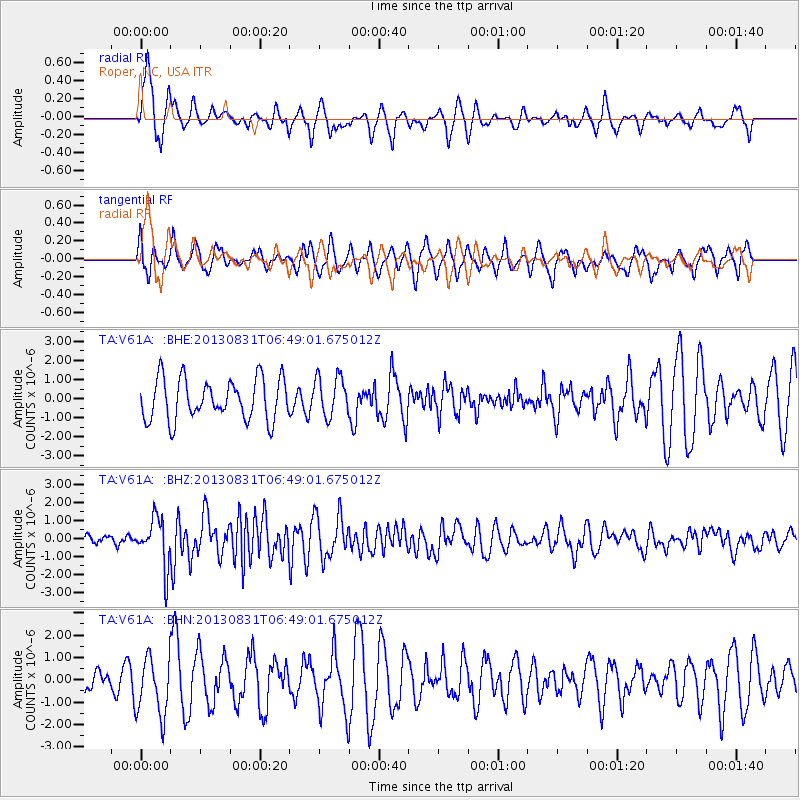
V61A Roper, NC, USA - Earthquake Result Viewer
*The percent match for this event was below the threshold and hence no stack was calculated.
| Earthquake location: |
Andreanof Islands, Aleutian Is. |
| Earthquake latitude/longitude: |
51.2/-174.9 |
| Earthquake time(UTC): |
2013/08/31 (243) 06:38:36 GMT |
| Earthquake Depth: |
18 km |
| Earthquake Magnitude: |
6.0 MWW, 5.5 ML, 5.9 MWB, 5.9 MWC, 6.0 MWC, 6.0 MI, 6.0 MWW |
| Earthquake Catalog/Contributor: |
NEIC PDE/NEIC COMCAT |
|
| Network: |
TA USArray Transportable Network (new EarthScope stations) |
| Station: |
V61A Roper, NC, USA |
| Lat/Lon: |
35.79 N/76.58 W |
| Elevation: |
4.0 m |
|
| Distance: |
67.8 deg |
| Az: |
60.344 deg |
| Baz: |
317.783 deg |
| Ray Param: |
$rayparam |
*The percent match for this event was below the threshold and hence was not used in the summary stack. |
|
| Radial Match: |
66.901825 % |
| Radial Bump: |
356 |
| Transverse Match: |
57.138256 % |
| Transverse Bump: |
353 |
| SOD ConfigId: |
626651 |
| Insert Time: |
2014-04-18 06:42:40.270 +0000 |
| GWidth: |
2.5 |
| Max Bumps: |
400 |
| Tol: |
0.001 |
|
Signal To Noise
| Channel | StoN | STA | LTA |
| TA:V61A: :BHZ:20130831T06:49:01.675012Z | 4.3452034 | 1.3383842E-6 | 3.080142E-7 |
| TA:V61A: :BHN:20130831T06:49:01.675012Z | 1.4516491 | 1.3203871E-6 | 9.095774E-7 |
| TA:V61A: :BHE:20130831T06:49:01.675012Z | 0.96893156 | 1.0475795E-6 | 1.0811698E-6 |
| Arrivals |
| Ps | |
| PpPs | |
| PsPs/PpSs | |


