You are here: Home > Network List > US - United States National Seismic Network Stations List
> Station GLMI Grayling, Michigan, USA > Earthquake Result Viewer
GLMI Grayling, Michigan, USA - Earthquake Result Viewer
*The percent match for this event was below the threshold and hence no stack was calculated.
| Earthquake location: |
Andreanof Islands, Aleutian Is. |
| Earthquake latitude/longitude: |
51.2/-174.9 |
| Earthquake time(UTC): |
2013/08/31 (243) 06:38:36 GMT |
| Earthquake Depth: |
18 km |
| Earthquake Magnitude: |
6.0 MWW, 5.5 ML, 5.9 MWB, 5.9 MWC, 6.0 MWC, 6.0 MI, 6.0 MWW |
| Earthquake Catalog/Contributor: |
NEIC PDE/NEIC COMCAT |
|
| Network: |
US United States National Seismic Network |
| Station: |
GLMI Grayling, Michigan, USA |
| Lat/Lon: |
44.82 N/84.62 W |
| Elevation: |
387 m |
|
| Distance: |
57.1 deg |
| Az: |
57.994 deg |
| Baz: |
311.488 deg |
| Ray Param: |
$rayparam |
*The percent match for this event was below the threshold and hence was not used in the summary stack. |
|
| Radial Match: |
48.870045 % |
| Radial Bump: |
400 |
| Transverse Match: |
58.94284 % |
| Transverse Bump: |
400 |
| SOD ConfigId: |
626651 |
| Insert Time: |
2014-04-18 06:45:51.228 +0000 |
| GWidth: |
2.5 |
| Max Bumps: |
400 |
| Tol: |
0.001 |
|
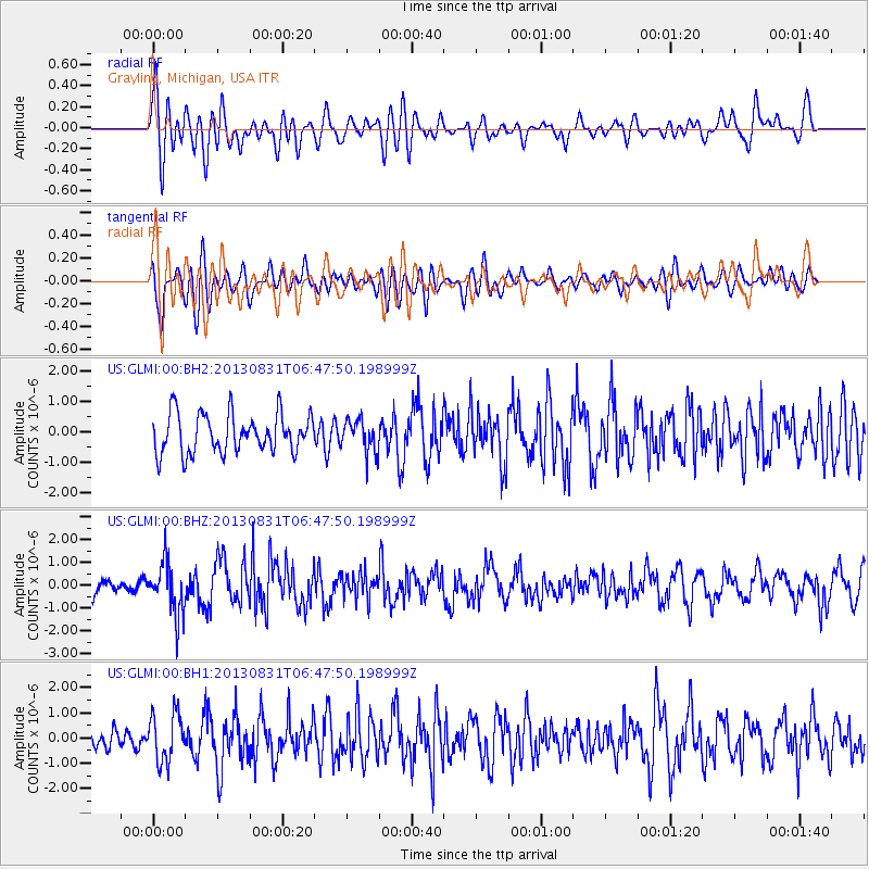
Signal To Noise
| Channel | StoN | STA | LTA |
| US:GLMI:00:BHZ:20130831T06:47:50.198999Z | 3.81806 | 1.1270596E-6 | 2.9519168E-7 |
| US:GLMI:00:BH1:20130831T06:47:50.198999Z | 1.2938405 | 9.542877E-7 | 7.3756206E-7 |
| US:GLMI:00:BH2:20130831T06:47:50.198999Z | 0.84013134 | 5.344143E-7 | 6.361081E-7 |
| Arrivals |
| Ps | |
| PpPs | |
| PsPs/PpSs | |


