You are here: Home > Network List > YQ13 - Study of Extension and Magmatism in Malawi and Tanzania Stations List
> Station NTHA Nthalire,Malawi > Earthquake Result Viewer
NTHA Nthalire,Malawi - Earthquake Result Viewer
| Earthquake location: |
Northern Molucca Sea |
| Earthquake latitude/longitude: |
1.9/126.5 |
| Earthquake time(UTC): |
2014/11/15 (319) 02:31:40 GMT |
| Earthquake Depth: |
35 km |
| Earthquake Magnitude: |
7.1 MWW, 7.0 MWW, 7.3 MI |
| Earthquake Catalog/Contributor: |
NEIC PDE/NEIC COMCAT |
|
| Network: |
YQ Study of Extension and Magmatism in Malawi and Tanzania |
| Station: |
NTHA Nthalire,Malawi |
| Lat/Lon: |
10.35 S/33.64 E |
| Elevation: |
1291 m |
|
| Distance: |
93.2 deg |
| Az: |
259.803 deg |
| Baz: |
88.632 deg |
| Ray Param: |
0.04129507 |
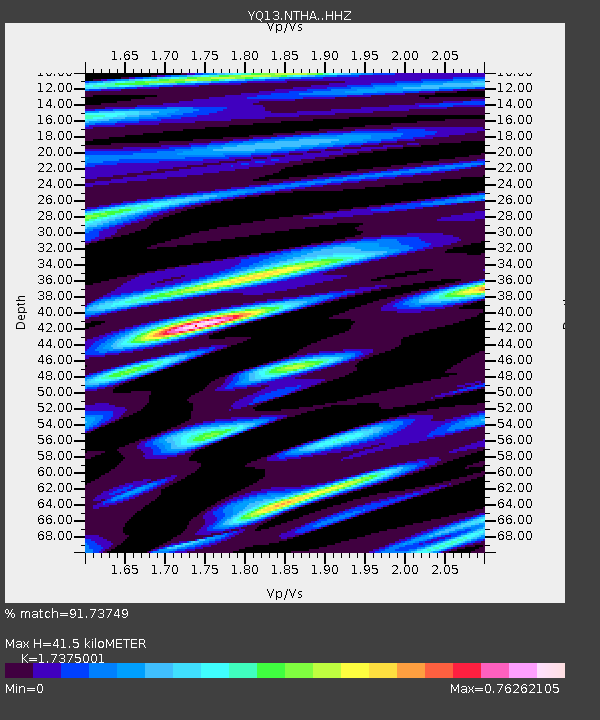
| Estimated Moho Depth: |
41.5 km |
| Estimated Crust Vp/Vs: |
1.74 |
| Assumed Crust Vp: |
6.367 km/s |
| Estimated Crust Vs: |
3.664 km/s |
| Estimated Crust Poisson's Ratio: |
0.25 |
|
| Radial Match: |
91.73749 % |
| Radial Bump: |
400 |
| Transverse Match: |
87.530754 % |
| Transverse Bump: |
400 |
| SOD ConfigId: |
3390531 |
| Insert Time: |
2019-04-15 00:13:32.779 +0000 |
| GWidth: |
2.5 |
| Max Bumps: |
400 |
| Tol: |
0.001 |
|

Signal To Noise
| Channel | StoN | STA | LTA |
| YQ:NTHA: :HHZ:20141115T02:44:19.700007Z | 8.854029 | 1.2089595E-6 | 1.3654343E-7 |
| YQ:NTHA: :HHN:20141115T02:44:19.700007Z | 0.3292728 | 4.159793E-8 | 1.2633272E-7 |
| YQ:NTHA: :HHE:20141115T02:44:19.700007Z | 2.4711823 | 3.270252E-7 | 1.3233553E-7 |
| Arrivals |
| Ps | 4.9 SECOND |
| PpPs | 17 SECOND |
| PsPs/PpSs | 22 SECOND |


