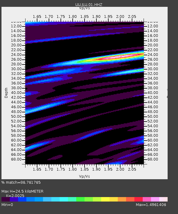
JLU Jordanelle, UT, USA - Earthquake Result Viewer

Earthquake location: Andreanof Islands, Aleutian Is.
Earthquake latitude/longitude: 51.2/-174.9
Earthquake time(UTC): 2013/08/31 (243) 06:38:36 GMT
Earthquake Depth: 18 km
Earthquake Magnitude: 6.0 MWW, 5.5 ML, 5.9 MWB, 5.9 MWC, 6.0 MWC, 6.0 MI, 6.0 MWW
Earthquake Catalog/Contributor: NEIC PDE/NEIC COMCAT
Network: UU University of Utah Regional Network
Station: JLU Jordanelle, UT, USA
Lat/Lon: 40.60 N/111.45 W
Elevation: 2285 m
Distance: 44.1 deg
Az: 78.128 deg
Baz: 306.102 deg
Ray Param: 0.0720878
Estimated Moho Depth: 24.5 km
Estimated Crust Vp/Vs: 2.00
Assumed Crust Vp: 6.155 km/s
Estimated Crust Vs: 3.074 km/s
Estimated Crust Poisson's Ratio: 0.33
Radial Match: 86.761765 %
Radial Bump: 400
Transverse Match: 70.20246 %
Transverse Bump: 400
SOD ConfigId: 626651
Insert Time: 2014-04-18 06:47:19.551 +0000
GWidth: 2.5
Max Bumps: 400
Tol: 0.001

Signal To Noise

ChannelStoNSTALTA
UU:JLU:01:HHZ:20130831T06:46:12.769006Z3.35615941.043849E-83.1102487E-9
UU:JLU:01:HHN:20130831T06:46:12.769006Z1.29764164.1281205E-93.1812486E-9
UU:JLU:01:HHE:20130831T06:46:12.769006Z1.61835994.3456643E-92.6852274E-9
Arrivals
Ps4.2 SECOND
PpPs11 SECOND
PsPs/PpSs16 SECOND