You are here: Home > Network List > YQ13 - Study of Extension and Magmatism in Malawi and Tanzania Stations List
> Station TOLA Matola,Tanzania > Earthquake Result Viewer
TOLA Matola,Tanzania - Earthquake Result Viewer
| Earthquake location: |
Northern Molucca Sea |
| Earthquake latitude/longitude: |
1.9/126.5 |
| Earthquake time(UTC): |
2014/11/15 (319) 02:31:40 GMT |
| Earthquake Depth: |
35 km |
| Earthquake Magnitude: |
7.1 MWW, 7.0 MWW, 7.3 MI |
| Earthquake Catalog/Contributor: |
NEIC PDE/NEIC COMCAT |
|
| Network: |
YQ Study of Extension and Magmatism in Malawi and Tanzania |
| Station: |
TOLA Matola,Tanzania |
| Lat/Lon: |
9.59 S/34.58 E |
| Elevation: |
2201 m |
|
| Distance: |
92.3 deg |
| Az: |
260.535 deg |
| Baz: |
88.435 deg |
| Ray Param: |
0.041477147 |
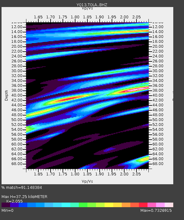
| Estimated Moho Depth: |
37.25 km |
| Estimated Crust Vp/Vs: |
2.06 |
| Assumed Crust Vp: |
6.576 km/s |
| Estimated Crust Vs: |
3.2 km/s |
| Estimated Crust Poisson's Ratio: |
0.34 |
|
| Radial Match: |
91.148384 % |
| Radial Bump: |
400 |
| Transverse Match: |
78.80209 % |
| Transverse Bump: |
400 |
| SOD ConfigId: |
3390531 |
| Insert Time: |
2019-04-15 00:13:34.327 +0000 |
| GWidth: |
2.5 |
| Max Bumps: |
400 |
| Tol: |
0.001 |
|

Signal To Noise
| Channel | StoN | STA | LTA |
| YQ:TOLA: :BHZ:20141115T02:44:15.325007Z | 4.1826396 | 1.2963392E-6 | 3.0993328E-7 |
| YQ:TOLA: :BHN:20141115T02:44:15.325007Z | 0.80225354 | 2.8056425E-7 | 3.4972018E-7 |
| YQ:TOLA: :BHE:20141115T02:44:15.325007Z | 1.5750104 | 5.9422143E-7 | 3.7728097E-7 |
| Arrivals |
| Ps | 6.1 SECOND |
| PpPs | 17 SECOND |
| PsPs/PpSs | 23 SECOND |


