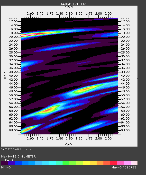
RDMU Red Mountain, UT, USA - Earthquake Result Viewer
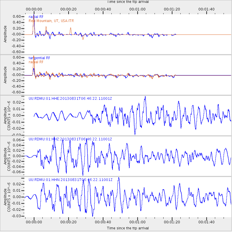
Earthquake location: Andreanof Islands, Aleutian Is.
Earthquake latitude/longitude: 51.2/-174.9
Earthquake time(UTC): 2013/08/31 (243) 06:38:36 GMT
Earthquake Depth: 18 km
Earthquake Magnitude: 6.0 MWW, 5.5 ML, 5.9 MWB, 5.9 MWC, 6.0 MWC, 6.0 MI, 6.0 MWW
Earthquake Catalog/Contributor: NEIC PDE/NEIC COMCAT
Network: UU University of Utah Regional Network
Station: RDMU Red Mountain, UT, USA
Lat/Lon: 40.57 N/109.57 W
Elevation: 2087 m
Distance: 45.3 deg
Az: 76.959 deg
Baz: 306.489 deg
Ray Param: 0.07134807
Estimated Moho Depth: 19.0 km
Estimated Crust Vp/Vs: 1.61
Assumed Crust Vp: 6.207 km/s
Estimated Crust Vs: 3.855 km/s
Estimated Crust Poisson's Ratio: 0.19
Radial Match: 93.53962 %
Radial Bump: 299
Transverse Match: 69.397415 %
Transverse Bump: 400
SOD ConfigId: 626651
Insert Time: 2014-04-18 06:47:38.191 +0000
GWidth: 2.5
Max Bumps: 400
Tol: 0.001

Signal To Noise

ChannelStoNSTALTA
UU:RDMU:01:HHZ:20130831T06:46:22.11001Z6.9080611.4513116E-82.1008957E-9
UU:RDMU:01:HHN:20130831T06:46:22.11001Z3.80024171.0395006E-82.735354E-9
UU:RDMU:01:HHE:20130831T06:46:22.11001Z1.52249635.355134E-93.5173378E-9
Arrivals
Ps2.0 SECOND
PpPs7.5 SECOND
PsPs/PpSs9.5 SECOND