You are here: Home > Network List > YQ13 - Study of Extension and Magmatism in Malawi and Tanzania Stations List
> Station WENY Wenya,Malawi > Earthquake Result Viewer
WENY Wenya,Malawi - Earthquake Result Viewer
| Earthquake location: |
Northern Molucca Sea |
| Earthquake latitude/longitude: |
1.9/126.5 |
| Earthquake time(UTC): |
2014/11/15 (319) 02:31:40 GMT |
| Earthquake Depth: |
35 km |
| Earthquake Magnitude: |
7.1 MWW, 7.0 MWW, 7.3 MI |
| Earthquake Catalog/Contributor: |
NEIC PDE/NEIC COMCAT |
|
| Network: |
YQ Study of Extension and Magmatism in Malawi and Tanzania |
| Station: |
WENY Wenya,Malawi |
| Lat/Lon: |
10.16 S/33.56 E |
| Elevation: |
1516 m |
|
| Distance: |
93.3 deg |
| Az: |
259.998 deg |
| Baz: |
88.636 deg |
| Ray Param: |
0.04128046 |
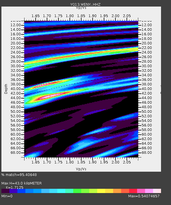
| Estimated Moho Depth: |
43.0 km |
| Estimated Crust Vp/Vs: |
1.71 |
| Assumed Crust Vp: |
6.367 km/s |
| Estimated Crust Vs: |
3.718 km/s |
| Estimated Crust Poisson's Ratio: |
0.24 |
|
| Radial Match: |
95.40648 % |
| Radial Bump: |
397 |
| Transverse Match: |
90.59229 % |
| Transverse Bump: |
400 |
| SOD ConfigId: |
3390531 |
| Insert Time: |
2019-04-15 00:13:38.223 +0000 |
| GWidth: |
2.5 |
| Max Bumps: |
400 |
| Tol: |
0.001 |
|

Signal To Noise
| Channel | StoN | STA | LTA |
| YQ:WENY: :HHZ:20141115T02:44:20.038997Z | 7.19154 | 1.0086947E-6 | 1.402613E-7 |
| YQ:WENY: :HHN:20141115T02:44:20.038997Z | 0.6728427 | 1.17769794E-7 | 1.7503318E-7 |
| YQ:WENY: :HHE:20141115T02:44:20.038997Z | 2.5535839 | 2.711738E-7 | 1.0619342E-7 |
| Arrivals |
| Ps | 4.9 SECOND |
| PpPs | 18 SECOND |
| PsPs/PpSs | 23 SECOND |


