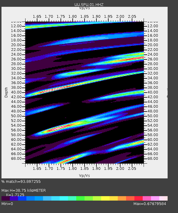
SPU South Promontory Point, UT, USA - Earthquake Result Viewer

Earthquake location: Andreanof Islands, Aleutian Is.
Earthquake latitude/longitude: 51.2/-174.9
Earthquake time(UTC): 2013/08/31 (243) 06:38:36 GMT
Earthquake Depth: 18 km
Earthquake Magnitude: 6.0 MWW, 5.5 ML, 5.9 MWB, 5.9 MWC, 6.0 MWC, 6.0 MI, 6.0 MWW
Earthquake Catalog/Contributor: NEIC PDE/NEIC COMCAT
Network: UU University of Utah Regional Network
Station: SPU South Promontory Point, UT, USA
Lat/Lon: 41.31 N/112.45 W
Elevation: 2086 m
Distance: 43.1 deg
Az: 77.937 deg
Baz: 305.311 deg
Ray Param: 0.07274816
Estimated Moho Depth: 38.75 km
Estimated Crust Vp/Vs: 1.71
Assumed Crust Vp: 6.276 km/s
Estimated Crust Vs: 3.665 km/s
Estimated Crust Poisson's Ratio: 0.24
Radial Match: 93.897255 %
Radial Bump: 249
Transverse Match: 82.00979 %
Transverse Bump: 400
SOD ConfigId: 626651
Insert Time: 2014-04-18 06:47:42.587 +0000
GWidth: 2.5
Max Bumps: 400
Tol: 0.001

Signal To Noise

ChannelStoNSTALTA
UU:SPU:01:HHZ:20130831T06:46:04.524988Z3.54172979.18582E-92.5935971E-9
UU:SPU:01:HHN:20130831T06:46:04.524988Z1.16525863.4151861E-92.9308396E-9
UU:SPU:01:HHE:20130831T06:46:04.524988Z0.85442043.616211E-94.232356E-9
Arrivals
Ps4.7 SECOND
PpPs16 SECOND
PsPs/PpSs20 SECOND