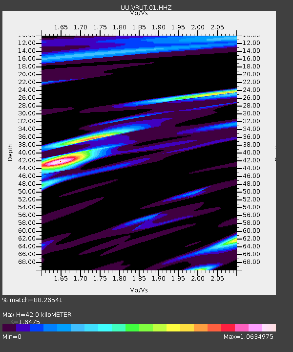
VRUT Veyo Road, Veyo, UT, USA - Earthquake Result Viewer

Earthquake location: Andreanof Islands, Aleutian Is.
Earthquake latitude/longitude: 51.2/-174.9
Earthquake time(UTC): 2013/08/31 (243) 06:38:36 GMT
Earthquake Depth: 18 km
Earthquake Magnitude: 6.0 MWW, 5.5 ML, 5.9 MWB, 5.9 MWC, 6.0 MWC, 6.0 MI, 6.0 MWW
Earthquake Catalog/Contributor: NEIC PDE/NEIC COMCAT
Network: UU University of Utah Regional Network
Station: VRUT Veyo Road, Veyo, UT, USA
Lat/Lon: 37.46 N/113.86 W
Elevation: 1874 m
Distance: 44.5 deg
Az: 83.325 deg
Baz: 308.31 deg
Ray Param: 0.07183992
Estimated Moho Depth: 42.0 km
Estimated Crust Vp/Vs: 1.65
Assumed Crust Vp: 6.194 km/s
Estimated Crust Vs: 3.76 km/s
Estimated Crust Poisson's Ratio: 0.21
Radial Match: 88.26541 %
Radial Bump: 349
Transverse Match: 69.50113 %
Transverse Bump: 400
SOD ConfigId: 626651
Insert Time: 2014-04-18 06:47:54.645 +0000
GWidth: 2.5
Max Bumps: 400
Tol: 0.001

Signal To Noise

ChannelStoNSTALTA
UU:VRUT:01:HHZ:20130831T06:46:15.990015Z2.8182185.9514345E-92.1117723E-9
UU:VRUT:01:HHN:20130831T06:46:15.990015Z1.35517683.5397103E-92.6119915E-9
UU:VRUT:01:HHE:20130831T06:46:15.990015Z1.40272133.885149E-92.769723E-9
Arrivals
Ps4.7 SECOND
PpPs17 SECOND
PsPs/PpSs22 SECOND