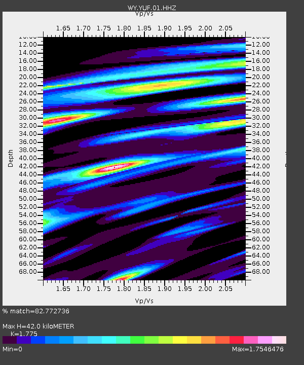
YUF Upper Falls, WY, USA - Earthquake Result Viewer

Earthquake location: Andreanof Islands, Aleutian Is.
Earthquake latitude/longitude: 51.2/-174.9
Earthquake time(UTC): 2013/08/31 (243) 06:38:36 GMT
Earthquake Depth: 18 km
Earthquake Magnitude: 6.0 MWW, 5.5 ML, 5.9 MWB, 5.9 MWC, 6.0 MWC, 6.0 MI, 6.0 MWW
Earthquake Catalog/Contributor: NEIC PDE/NEIC COMCAT
Network: WY Yellowstone Wyoming Seismic Network
Station: YUF Upper Falls, WY, USA
Lat/Lon: 44.71 N/110.51 W
Elevation: 2394 m
Distance: 42.4 deg
Az: 72.609 deg
Baz: 302.714 deg
Ray Param: 0.07319175
Estimated Moho Depth: 42.0 km
Estimated Crust Vp/Vs: 1.77
Assumed Crust Vp: 6.35 km/s
Estimated Crust Vs: 3.577 km/s
Estimated Crust Poisson's Ratio: 0.27
Radial Match: 82.772736 %
Radial Bump: 400
Transverse Match: 53.985863 %
Transverse Bump: 400
SOD ConfigId: 626651
Insert Time: 2014-04-18 06:49:53.344 +0000
GWidth: 2.5
Max Bumps: 400
Tol: 0.001

Signal To Noise

ChannelStoNSTALTA
WY:YUF:01:HHZ:20130831T06:45:58.644006Z2.68193861.5561893E-85.8024794E-9
WY:YUF:01:HHN:20130831T06:45:58.644006Z1.29851871.1093372E-88.543099E-9
WY:YUF:01:HHE:20130831T06:45:58.644006Z1.33865131.3291519E-89.929038E-9
Arrivals
Ps5.5 SECOND
PpPs17 SECOND
PsPs/PpSs23 SECOND