You are here: Home > Network List > ZV14 - Southern Lake Tanganyika experiment Stations List
> Station LAEA LAELA > Earthquake Result Viewer
LAEA LAELA - Earthquake Result Viewer
| Earthquake location: |
Northern Molucca Sea |
| Earthquake latitude/longitude: |
1.9/126.5 |
| Earthquake time(UTC): |
2014/11/15 (319) 02:31:40 GMT |
| Earthquake Depth: |
35 km |
| Earthquake Magnitude: |
7.1 MWW, 7.0 MWW, 7.3 MI |
| Earthquake Catalog/Contributor: |
NEIC PDE/NEIC COMCAT |
|
| Network: |
ZV Southern Lake Tanganyika experiment |
| Station: |
LAEA LAELA |
| Lat/Lon: |
8.58 S/32.04 E |
| Elevation: |
1568 m |
|
| Distance: |
94.7 deg |
| Az: |
261.606 deg |
| Baz: |
88.768 deg |
| Ray Param: |
0.04095254 |
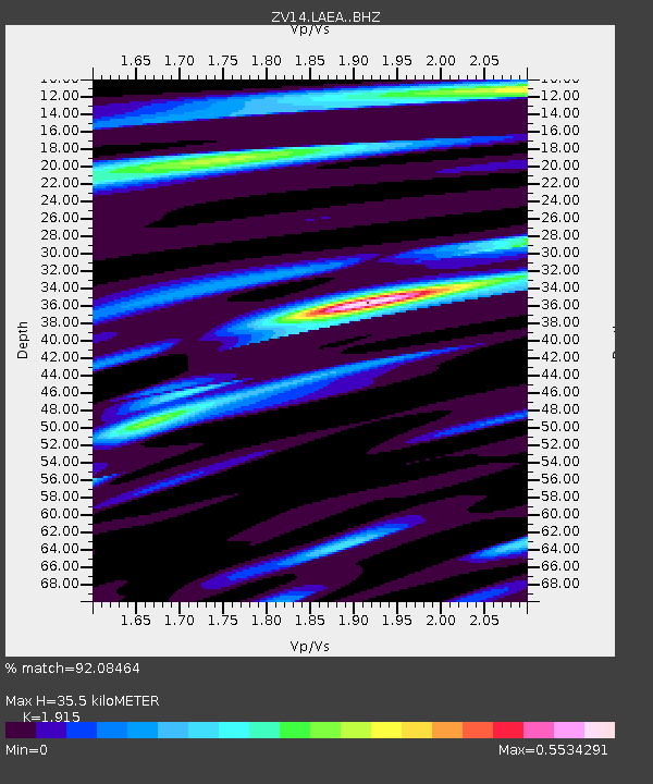
| Estimated Moho Depth: |
35.5 km |
| Estimated Crust Vp/Vs: |
1.91 |
| Assumed Crust Vp: |
6.502 km/s |
| Estimated Crust Vs: |
3.395 km/s |
| Estimated Crust Poisson's Ratio: |
0.31 |
|
| Radial Match: |
92.08464 % |
| Radial Bump: |
262 |
| Transverse Match: |
83.229385 % |
| Transverse Bump: |
400 |
| SOD ConfigId: |
3390531 |
| Insert Time: |
2019-04-15 00:14:07.769 +0000 |
| GWidth: |
2.5 |
| Max Bumps: |
400 |
| Tol: |
0.001 |
|

Signal To Noise
| Channel | StoN | STA | LTA |
| ZV:LAEA: :BHZ:20141115T02:44:26.720027Z | 8.96256 | 7.7759745E-7 | 8.676065E-8 |
| ZV:LAEA: :BHN:20141115T02:44:26.720027Z | 1.397443 | 1.0270332E-7 | 7.3493744E-8 |
| ZV:LAEA: :BHE:20141115T02:44:26.720027Z | 1.98289 | 2.4537798E-7 | 1.2374764E-7 |
| Arrivals |
| Ps | 5.1 SECOND |
| PpPs | 16 SECOND |
| PsPs/PpSs | 21 SECOND |


