You are here: Home > Network List > PF - Volcanologic Network of Piton de Fournaise-OVPF Stations List
> Station HIM cratere Himiltrude > Earthquake Result Viewer
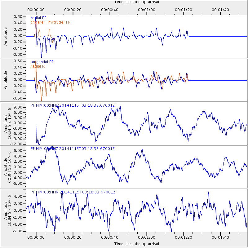
HIM cratere Himiltrude - Earthquake Result Viewer
*The percent match for this event was below the threshold and hence no stack was calculated.
| Earthquake location: |
Minahassa Peninsula, Sulawesi |
| Earthquake latitude/longitude: |
-0.1/123.9 |
| Earthquake time(UTC): |
2014/11/15 (319) 03:08:04 GMT |
| Earthquake Depth: |
85 km |
| Earthquake Magnitude: |
5.8 MB |
| Earthquake Catalog/Contributor: |
NEIC PDE/NEIC COMCAT |
|
| Network: |
PF Volcanologic Network of Piton de Fournaise-OVPF |
| Station: |
HIM cratere Himiltrude |
| Lat/Lon: |
21.21 S/55.72 E |
| Elevation: |
1958 m |
|
| Distance: |
69.7 deg |
| Az: |
247.499 deg |
| Baz: |
81.948 deg |
| Ray Param: |
$rayparam |
*The percent match for this event was below the threshold and hence was not used in the summary stack. |
|
| Radial Match: |
78.64126 % |
| Radial Bump: |
364 |
| Transverse Match: |
58.356102 % |
| Transverse Bump: |
400 |
| SOD ConfigId: |
3390531 |
| Insert Time: |
2019-04-15 00:19:14.794 +0000 |
| GWidth: |
2.5 |
| Max Bumps: |
400 |
| Tol: |
0.001 |
|
Signal To Noise
| Channel | StoN | STA | LTA |
| PF:HIM:00:HHZ:20141115T03:18:33.67001Z | 0.41655996 | 1.5478926E-6 | 3.7158936E-6 |
| PF:HIM:00:HHN:20141115T03:18:33.67001Z | 1.2684051 | 2.4237315E-6 | 1.9108497E-6 |
| PF:HIM:00:HHE:20141115T03:18:33.67001Z | 1.226461 | 7.2217467E-6 | 5.88828E-6 |
| Arrivals |
| Ps | |
| PpPs | |
| PsPs/PpSs | |


