You are here: Home > Network List > AV - Alaska Volcano Observatory Stations List
> Station SPCR Ckakachatna River, Mount Spurr, Alaska > Earthquake Result Viewer
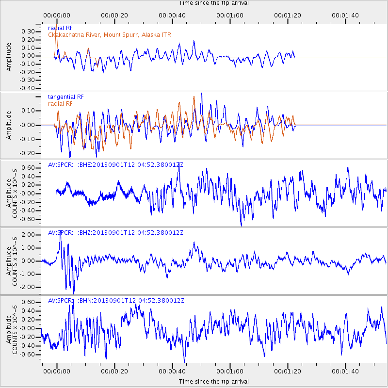
SPCR Ckakachatna River, Mount Spurr, Alaska - Earthquake Result Viewer
*The percent match for this event was below the threshold and hence no stack was calculated.
| Earthquake location: |
Banda Sea |
| Earthquake latitude/longitude: |
-7.4/128.2 |
| Earthquake time(UTC): |
2013/09/01 (244) 11:52:29 GMT |
| Earthquake Depth: |
112 km |
| Earthquake Magnitude: |
6.5 MWW, 6.4 MWC, 6.4 MWD, 6.5 MWW, 6.5 MWB, 6.5 MWC |
| Earthquake Catalog/Contributor: |
NEIC PDE/NEIC COMCAT |
|
| Network: |
AV Alaska Volcano Observatory |
| Station: |
SPCR Ckakachatna River, Mount Spurr, Alaska |
| Lat/Lon: |
61.20 N/152.21 W |
| Elevation: |
984 m |
|
| Distance: |
91.5 deg |
| Az: |
28.45 deg |
| Baz: |
257.324 deg |
| Ray Param: |
$rayparam |
*The percent match for this event was below the threshold and hence was not used in the summary stack. |
|
| Radial Match: |
54.829144 % |
| Radial Bump: |
400 |
| Transverse Match: |
63.999096 % |
| Transverse Bump: |
400 |
| SOD ConfigId: |
626651 |
| Insert Time: |
2014-04-18 07:17:30.597 +0000 |
| GWidth: |
2.5 |
| Max Bumps: |
400 |
| Tol: |
0.001 |
|
Signal To Noise
| Channel | StoN | STA | LTA |
| AV:SPCR: :BHZ:20130901T12:04:52.380012Z | 8.0384245 | 1.1124524E-6 | 1.3839185E-7 |
| AV:SPCR: :BHN:20130901T12:04:52.380012Z | 1.2386943 | 3.5088215E-7 | 2.8326775E-7 |
| AV:SPCR: :BHE:20130901T12:04:52.380012Z | 1.5528824 | 1.9218385E-7 | 1.2375943E-7 |
| Arrivals |
| Ps | |
| PpPs | |
| PsPs/PpSs | |


