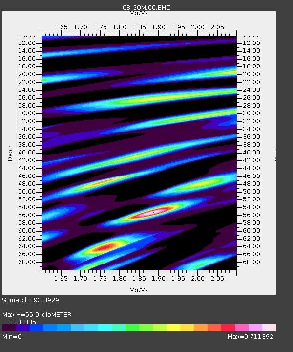
GOM Geermu,Qinghai Province - Earthquake Result Viewer

Earthquake location: Banda Sea
Earthquake latitude/longitude: -7.4/128.2
Earthquake time(UTC): 2013/09/01 (244) 11:52:29 GMT
Earthquake Depth: 112 km
Earthquake Magnitude: 6.5 MWW, 6.4 MWC, 6.4 MWD, 6.5 MWW, 6.5 MWB, 6.5 MWC
Earthquake Catalog/Contributor: NEIC PDE/NEIC COMCAT
Network: CB China National Seismic Network
Station: GOM Geermu,Qinghai Province
Lat/Lon: 36.20 N/94.81 E
Elevation: 3121 m
Distance: 53.6 deg
Az: 326.388 deg
Baz: 137.258 deg
Ray Param: 0.065656155
Estimated Moho Depth: 55.0 km
Estimated Crust Vp/Vs: 1.88
Assumed Crust Vp: 6.385 km/s
Estimated Crust Vs: 3.387 km/s
Estimated Crust Poisson's Ratio: 0.30
Radial Match: 93.3929 %
Radial Bump: 400
Transverse Match: 85.231995 %
Transverse Bump: 400
SOD ConfigId: 626651
Insert Time: 2014-04-18 07:17:39.309 +0000
GWidth: 2.5
Max Bumps: 400
Tol: 0.001

Signal To Noise

ChannelStoNSTALTA
CB:GOM:00:BHZ:20130901T12:01:08.649971Z38.605553.6949752E-69.571099E-8
CB:GOM:00:BHN:20130901T12:01:08.649971Z35.4464761.0176112E-62.8708389E-8
CB:GOM:00:BHE:20130901T12:01:08.649971Z17.895577.2414787E-74.04652E-8
Arrivals
Ps8.0 SECOND
PpPs24 SECOND
PsPs/PpSs32 SECOND