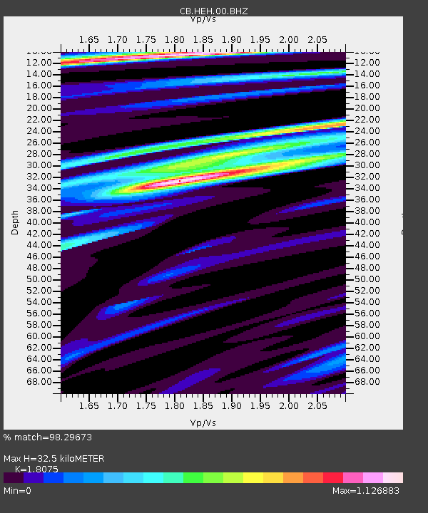
HEH Heihe,Heilongjiang Province - Earthquake Result Viewer
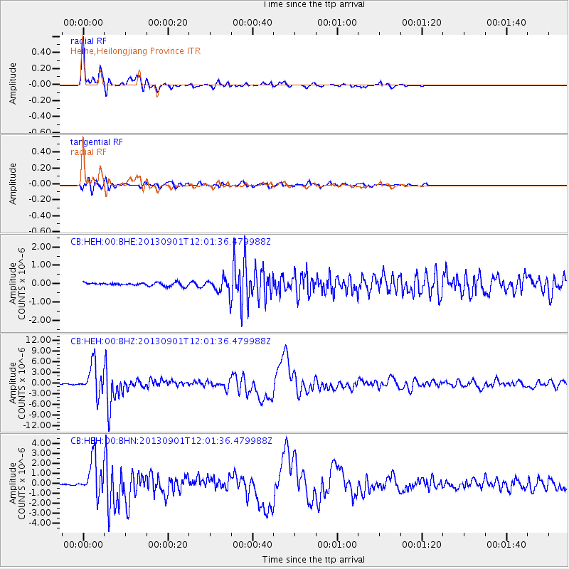
Earthquake location: Banda Sea
Earthquake latitude/longitude: -7.4/128.2
Earthquake time(UTC): 2013/09/01 (244) 11:52:29 GMT
Earthquake Depth: 112 km
Earthquake Magnitude: 6.5 MWW, 6.4 MWC, 6.4 MWD, 6.5 MWW, 6.5 MWB, 6.5 MWC
Earthquake Catalog/Contributor: NEIC PDE/NEIC COMCAT
Network: CB China National Seismic Network
Station: HEH Heihe,Heilongjiang Province
Lat/Lon: 50.25 N/127.41 E
Elevation: 165 m
Distance: 57.5 deg
Az: 359.383 deg
Baz: 179.046 deg
Ray Param: 0.06314605
Estimated Moho Depth: 32.5 km
Estimated Crust Vp/Vs: 1.81
Assumed Crust Vp: 6.419 km/s
Estimated Crust Vs: 3.551 km/s
Estimated Crust Poisson's Ratio: 0.28
Radial Match: 98.29673 %
Radial Bump: 249
Transverse Match: 88.29518 %
Transverse Bump: 400
SOD ConfigId: 626651
Insert Time: 2014-04-18 07:17:47.440 +0000
GWidth: 2.5
Max Bumps: 400
Tol: 0.001

Signal To Noise

ChannelStoNSTALTA
CB:HEH:00:BHZ:20130901T12:01:36.479988Z48.2839284.282853E-68.870141E-8
CB:HEH:00:BHN:20130901T12:01:36.479988Z29.9194451.8976431E-66.342508E-8
CB:HEH:00:BHE:20130901T12:01:36.479988Z4.86073354.1222063E-78.480626E-8
Arrivals
Ps4.3 SECOND
PpPs14 SECOND
PsPs/PpSs18 SECOND