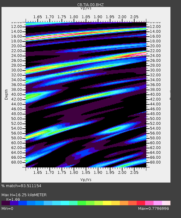
TIA Taian,Shandong Province - Earthquake Result Viewer

Earthquake location: Banda Sea
Earthquake latitude/longitude: -7.4/128.2
Earthquake time(UTC): 2013/09/01 (244) 11:52:29 GMT
Earthquake Depth: 112 km
Earthquake Magnitude: 6.5 MWW, 6.4 MWC, 6.4 MWD, 6.5 MWW, 6.5 MWB, 6.5 MWC
Earthquake Catalog/Contributor: NEIC PDE/NEIC COMCAT
Network: CB China National Seismic Network
Station: TIA Taian,Shandong Province
Lat/Lon: 36.21 N/117.12 E
Elevation: 267 m
Distance: 44.7 deg
Az: 347.204 deg
Baz: 164.242 deg
Ray Param: 0.07139154
Estimated Moho Depth: 16.25 km
Estimated Crust Vp/Vs: 1.66
Assumed Crust Vp: 6.363 km/s
Estimated Crust Vs: 3.833 km/s
Estimated Crust Poisson's Ratio: 0.22
Radial Match: 93.511154 %
Radial Bump: 400
Transverse Match: 67.653015 %
Transverse Bump: 400
SOD ConfigId: 626651
Insert Time: 2014-04-18 07:18:00.847 +0000
GWidth: 2.5
Max Bumps: 400
Tol: 0.001

Signal To Noise

ChannelStoNSTALTA
CB:TIA:00:BHZ:20130901T12:00:00.94001Z24.8844784.204507E-61.6896102E-7
CB:TIA:00:BHN:20130901T12:00:00.94001Z13.899772.2176841E-61.5954825E-7
CB:TIA:00:BHE:20130901T12:00:00.94001Z6.9763216.7875845E-79.729461E-8
Arrivals
Ps1.8 SECOND
PpPs6.4 SECOND
PsPs/PpSs8.2 SECOND