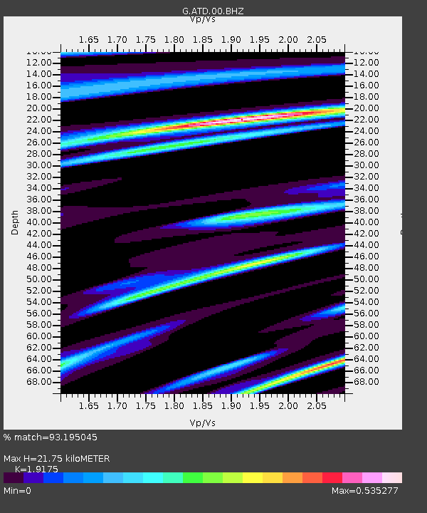
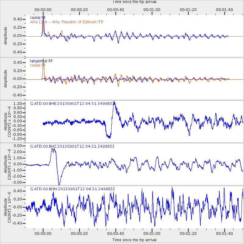
ATD Arta Cave - Arta, Republic of Djibouti - Earthquake Result Viewer

Earthquake location: Banda Sea
Earthquake latitude/longitude: -7.4/128.2
Earthquake time(UTC): 2013/09/01 (244) 11:52:29 GMT
Earthquake Depth: 112 km
Earthquake Magnitude: 6.5 MWW, 6.4 MWC, 6.4 MWD, 6.5 MWW, 6.5 MWB, 6.5 MWC
Earthquake Catalog/Contributor: NEIC PDE/NEIC COMCAT
Network: G GEOSCOPE
Station: ATD Arta Cave - Arta, Republic of Djibouti
Lat/Lon: 11.53 N/42.85 E
Elevation: 610 m
Distance: 87.0 deg
Az: 281.971 deg
Baz: 98.173 deg
Ray Param: 0.04342173
Estimated Moho Depth: 21.75 km
Estimated Crust Vp/Vs: 1.92
Assumed Crust Vp: 6.375 km/s
Estimated Crust Vs: 3.325 km/s
Estimated Crust Poisson's Ratio: 0.31
Radial Match: 93.195045 %
Radial Bump: 400
Transverse Match: 77.72714 %
Transverse Bump: 400
SOD ConfigId: 626651
Insert Time: 2014-04-18 07:18:17.400 +0000
GWidth: 2.5
Max Bumps: 400
Tol: 0.001

Signal To Noise

ChannelStoNSTALTA
G:ATD:00:BHZ:20130901T12:04:31.349983Z10.7015127.821364E-77.308653E-8
G:ATD:00:BHN:20130901T12:04:31.349983Z1.05181268.362347E-87.9504154E-8
G:ATD:00:BHE:20130901T12:04:31.349983Z2.11716991.8594807E-78.7828596E-8
Arrivals
Ps3.2 SECOND
PpPs9.8 SECOND
PsPs/PpSs13 SECOND