You are here: Home > Network List > G - GEOSCOPE Stations List
> Station INU Inuyama, Japan > Earthquake Result Viewer
INU Inuyama, Japan - Earthquake Result Viewer
| Earthquake location: |
Banda Sea |
| Earthquake latitude/longitude: |
-7.4/128.2 |
| Earthquake time(UTC): |
2013/09/01 (244) 11:52:29 GMT |
| Earthquake Depth: |
112 km |
| Earthquake Magnitude: |
6.5 MWW, 6.4 MWC, 6.4 MWD, 6.5 MWW, 6.5 MWB, 6.5 MWC |
| Earthquake Catalog/Contributor: |
NEIC PDE/NEIC COMCAT |
|
| Network: |
G GEOSCOPE |
| Station: |
INU Inuyama, Japan |
| Lat/Lon: |
35.35 N/137.03 E |
| Elevation: |
132 m |
|
| Distance: |
43.4 deg |
| Az: |
10.504 deg |
| Baz: |
192.777 deg |
| Ray Param: |
0.07219519 |
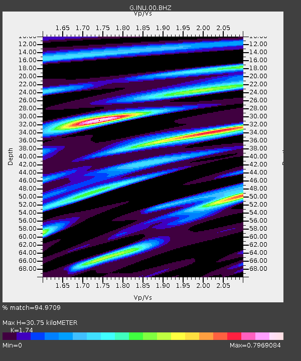
| Estimated Moho Depth: |
30.75 km |
| Estimated Crust Vp/Vs: |
1.74 |
| Assumed Crust Vp: |
6.461 km/s |
| Estimated Crust Vs: |
3.713 km/s |
| Estimated Crust Poisson's Ratio: |
0.25 |
|
| Radial Match: |
94.9709 % |
| Radial Bump: |
400 |
| Transverse Match: |
82.764404 % |
| Transverse Bump: |
400 |
| SOD ConfigId: |
626651 |
| Insert Time: |
2014-04-18 07:18:27.781 +0000 |
| GWidth: |
2.5 |
| Max Bumps: |
400 |
| Tol: |
0.001 |
|

Signal To Noise
| Channel | StoN | STA | LTA |
| G:INU:00:BHZ:20130901T11:59:50.660988Z | 20.292152 | 2.9626065E-6 | 1.4599765E-7 |
| G:INU:00:BHN:20130901T11:59:50.660988Z | 8.702587 | 1.5003302E-6 | 1.7240048E-7 |
| G:INU:00:BHE:20130901T11:59:50.660988Z | 8.479156 | 7.991238E-7 | 9.4245685E-8 |
| Arrivals |
| Ps | 3.8 SECOND |
| PpPs | 12 SECOND |
| PsPs/PpSs | 16 SECOND |


