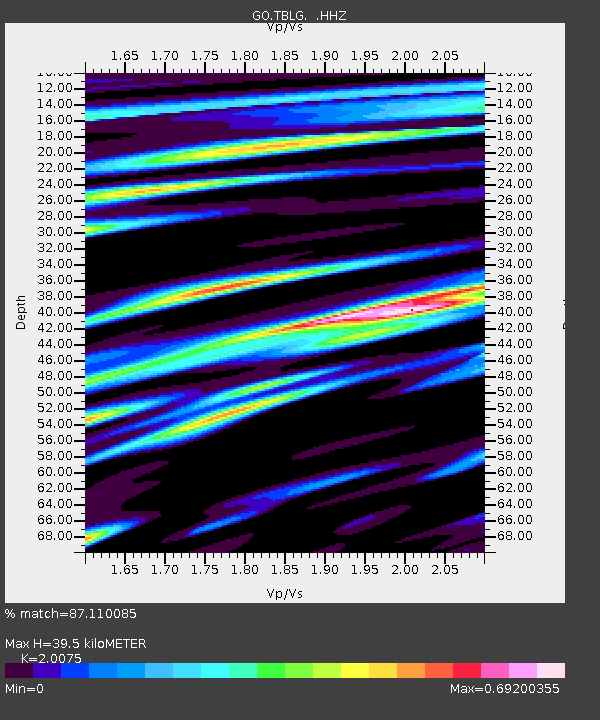
TBLG Delisi, Georgia - Earthquake Result Viewer

Earthquake location: Banda Sea
Earthquake latitude/longitude: -7.4/128.2
Earthquake time(UTC): 2013/09/01 (244) 11:52:29 GMT
Earthquake Depth: 112 km
Earthquake Magnitude: 6.5 MWW, 6.4 MWC, 6.4 MWD, 6.5 MWW, 6.5 MWB, 6.5 MWC
Earthquake Catalog/Contributor: NEIC PDE/NEIC COMCAT
Network: GO National Seismic Network of Georgia
Station: TBLG Delisi, Georgia
Lat/Lon: 41.73 N/44.74 E
Elevation: 510 m
Distance: 90.1 deg
Az: 311.956 deg
Baz: 99.842 deg
Ray Param: 0.041677956
Estimated Moho Depth: 39.5 km
Estimated Crust Vp/Vs: 2.01
Assumed Crust Vp: 6.291 km/s
Estimated Crust Vs: 3.134 km/s
Estimated Crust Poisson's Ratio: 0.33
Radial Match: 87.110085 %
Radial Bump: 400
Transverse Match: 78.15653 %
Transverse Bump: 400
SOD ConfigId: 626651
Insert Time: 2014-04-18 07:19:01.686 +0000
GWidth: 2.5
Max Bumps: 400
Tol: 0.001

Signal To Noise

ChannelStoNSTALTA
GO:TBLG: :HHZ:20130901T12:04:45.870002Z22.4152551.6920997E-67.548876E-8
GO:TBLG: :HHN:20130901T12:04:45.870002Z3.3062312.1661351E-76.551675E-8
GO:TBLG: :HHE:20130901T12:04:45.870002Z8.8973765.432188E-76.105382E-8
Arrivals
Ps6.4 SECOND
PpPs19 SECOND
PsPs/PpSs25 SECOND