You are here: Home > Network List > IC - New China Digital Seismograph Network Stations List
> Station MDJ Mudanjiang, Heilongjiang Province, China > Earthquake Result Viewer
MDJ Mudanjiang, Heilongjiang Province, China - Earthquake Result Viewer

| Earthquake location: |
Banda Sea |
| Earthquake latitude/longitude: |
-7.4/128.2 |
| Earthquake time(UTC): |
2013/09/01 (244) 11:52:29 GMT |
| Earthquake Depth: |
112 km |
| Earthquake Magnitude: |
6.5 MWW, 6.4 MWC, 6.4 MWD, 6.5 MWW, 6.5 MWB, 6.5 MWC |
| Earthquake Catalog/Contributor: |
NEIC PDE/NEIC COMCAT |
|
| Network: |
IC New China Digital Seismograph Network |
| Station: |
MDJ Mudanjiang, Heilongjiang Province, China |
| Lat/Lon: |
44.62 N/129.59 E |
| Elevation: |
270 m |
|
| Distance: |
51.8 deg |
| Az: |
1.244 deg |
| Baz: |
181.728 deg |
| Ray Param: |
0.066791795 |
| Estimated Moho Depth: |
35.5 km |
| Estimated Crust Vp/Vs: |
1.85 |
| Assumed Crust Vp: |
6.459 km/s |
| Estimated Crust Vs: |
3.487 km/s |
| Estimated Crust Poisson's Ratio: |
0.29 |
|
| Radial Match: |
97.44936 % |
| Radial Bump: |
340 |
| Transverse Match: |
88.61876 % |
| Transverse Bump: |
400 |
| SOD ConfigId: |
626651 |
| Insert Time: |
2014-04-18 07:19:44.048 +0000 |
| GWidth: |
2.5 |
| Max Bumps: |
400 |
| Tol: |
0.001 |
|
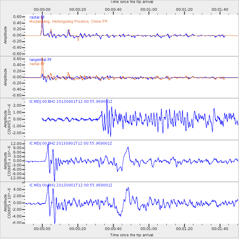
Signal To Noise
| Channel | StoN | STA | LTA |
| IC:MDJ:00:BHZ:20130901T12:00:55.969001Z | 26.666584 | 4.5414713E-6 | 1.703057E-7 |
| IC:MDJ:00:BH1:20130901T12:00:55.969001Z | 13.684362 | 2.2016966E-6 | 1.6089143E-7 |
| IC:MDJ:00:BH2:20130901T12:00:55.969001Z | 4.7188334 | 5.887778E-7 | 1.247719E-7 |
| Arrivals |
| Ps | 4.9 SECOND |
| PpPs | 15 SECOND |
| PsPs/PpSs | 20 SECOND |


